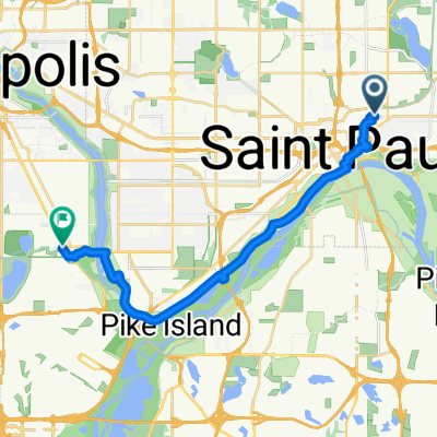
B2B00062 55106 - 55075 via Concord, NURT
A cycling route starting in Saint Paul, Minnesota, United States of America.
Overview
About this route
Beginning at the Wabasha Street Bridge, there are nice bike lanes extending along Wabasha, Cesar Chavez, and Concord before ending at Annapolis Street. Te shoulder of Concord should be fine to connect the gap between the end of the bike lanes and Kaposia Park.Â
Â
At Kaposia Park, cut through the parking lot and get on the bike trail that crosses over Concord on a pedestrian-style bridge. This is the South Saint Paul segment of the North Urban Regional Trail system. Follow the trail until you see an obvious ramp and bridge allowing you to cross the tracks and leave the trail at Grand Avenue.
- -:--
- Duration
- 9.5 km
- Distance
- 80 m
- Ascent
- 110 m
- Descent
- ---
- Avg. speed
- 242 m
- Max. altitude
Route quality
Waytypes & surfaces along the route
Waytypes
Cycleway
4.4 km
(47 %)
Busy road
3 km
(31 %)
Surfaces
Paved
7.6 km
(80 %)
Asphalt
5.7 km
(60 %)
Paved (undefined)
1.7 km
(18 %)
Continue with Bikemap
Use, edit, or download this cycling route
You would like to ride B2B00062 55106 - 55075 via Concord, NURT or customize it for your own trip? Here is what you can do with this Bikemap route:
Free features
- Save this route as favorite or in collections
- Copy & plan your own version of this route
- Sync your route with Garmin or Wahoo
Premium features
Free trial for 3 days, or one-time payment. More about Bikemap Premium.
- Navigate this route on iOS & Android
- Export a GPX / KML file of this route
- Create your custom printout (try it for free)
- Download this route for offline navigation
Discover more Premium features.
Get Bikemap PremiumFrom our community
Other popular routes starting in Saint Paul
- River Ramble 20
- Distance
- 29.6 km
- Ascent
- 196 m
- Descent
- 197 m
- Location
- Saint Paul, Minnesota, United States of America
- Gateway State Trail
- Distance
- 30 km
- Ascent
- 115 m
- Descent
- 69 m
- Location
- Saint Paul, Minnesota, United States of America
- B2B00192 55102>55404viaShepherdRd/MissBlvd/WRiverPkwy/MidtwnGrnway
- Distance
- 21.8 km
- Ascent
- 131 m
- Descent
- 86 m
- Location
- Saint Paul, Minnesota, United States of America
- B2B00024 55104 > 55121 via Big Rivers Trail
- Distance
- 16.8 km
- Ascent
- 174 m
- Descent
- 174 m
- Location
- Saint Paul, Minnesota, United States of America
- B2B00062 55106 - 55075 via Concord, NURT
- Distance
- 9.5 km
- Ascent
- 80 m
- Descent
- 110 m
- Location
- Saint Paul, Minnesota, United States of America
- St Paul Gateway to: Brown’s creek to Stillwater and back .
- Distance
- 64.2 km
- Ascent
- 408 m
- Descent
- 409 m
- Location
- Saint Paul, Minnesota, United States of America
- To the River Center
- Distance
- 17.1 km
- Ascent
- 117 m
- Descent
- 90 m
- Location
- Saint Paul, Minnesota, United States of America
- Way to Church
- Distance
- 13.2 km
- Ascent
- 54 m
- Descent
- 37 m
- Location
- Saint Paul, Minnesota, United States of America
Open it in the app