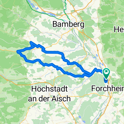
Herrenausflug zur Bärenschlucht
A cycling route starting in Eggolsheim, Bavaria, Germany.
Overview
About this route
<p>Eggolsheim to Bärenschlucht (near Pottenstein) via</p>
<ol>
<li> Bammersdorf</li>
<li> Ebermannstadt</li>
<li> Neideck Castle Ruins</li>
<li> along the Wiesent (river)</li>
<li> Muggendorf</li>
<li> Saschsenmühle</li>
<li> Behringersmühle</li>
<li> along the Püttlach</li>
<li> Bärenschlucht</li>
</ol>
Translated, show original (German)- -:--
- Duration
- 37.8 km
- Distance
- 359 m
- Ascent
- 254 m
- Descent
- ---
- Avg. speed
- ---
- Max. altitude
Route quality
Waytypes & surfaces along the route
Waytypes
Track
19.3 km
(51 %)
Quiet road
7.2 km
(19 %)
Surfaces
Paved
13.6 km
(36 %)
Unpaved
17.7 km
(47 %)
Asphalt
13.2 km
(35 %)
Gravel
9.1 km
(24 %)
Continue with Bikemap
Use, edit, or download this cycling route
You would like to ride Herrenausflug zur Bärenschlucht or customize it for your own trip? Here is what you can do with this Bikemap route:
Free features
- Save this route as favorite or in collections
- Copy & plan your own version of this route
- Sync your route with Garmin or Wahoo
Premium features
Free trial for 3 days, or one-time payment. More about Bikemap Premium.
- Navigate this route on iOS & Android
- Export a GPX / KML file of this route
- Create your custom printout (try it for free)
- Download this route for offline navigation
Discover more Premium features.
Get Bikemap PremiumFrom our community
Other popular routes starting in Eggolsheim
- Mai-Tour Franken-Pedalos
- Distance
- 16 km
- Ascent
- 171 m
- Descent
- 171 m
- Location
- Eggolsheim, Bavaria, Germany
- 2.Etappe 160 -40 möglich
- Distance
- 158.9 km
- Ascent
- 250 m
- Descent
- 153 m
- Location
- Eggolsheim, Bavaria, Germany
- Herrenausflug zur Bärenschlucht
- Distance
- 37.8 km
- Ascent
- 324 m
- Descent
- 219 m
- Location
- Eggolsheim, Bavaria, Germany
- Forchheim_Huppendorf_Steinfeld
- Distance
- 87.7 km
- Ascent
- 635 m
- Descent
- 636 m
- Location
- Eggolsheim, Bavaria, Germany
- Eggolsheim-Feuerstein, Fränkische Schweiz
- Distance
- 17.7 km
- Ascent
- 335 m
- Descent
- 223 m
- Location
- Eggolsheim, Bavaria, Germany
- Zur Staustufe nach Faber-Castell-Allee
- Distance
- 47 km
- Ascent
- 225 m
- Descent
- 154 m
- Location
- Eggolsheim, Bavaria, Germany
- Sprint Bei Gegenwind
- Distance
- 42.6 km
- Ascent
- 839 m
- Descent
- 840 m
- Location
- Eggolsheim, Bavaria, Germany
- Burker Waldrunde
- Distance
- 15.6 km
- Ascent
- 98 m
- Descent
- 98 m
- Location
- Eggolsheim, Bavaria, Germany
Open it in the app