

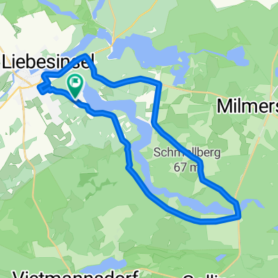
Spur der Steine zwischen Templin und Prenzlau
A cycling route starting in Templin, Brandenburg, Germany.
Overview
About this route
<p>Start at the Templin train station. We follow the path of stones to Boitzenburg. Following the Boitzenburger Stream, we pass by the watermills in Boitzenburg and Gollmitz towards Prenzlau.</p>
Translated, show original (German)- -:--
- Duration
- 51.7 km
- Distance
- 206 m
- Ascent
- 241 m
- Descent
- ---
- Avg. speed
- ---
- Max. altitude

Route quality
Waytypes & surfaces along the route
Waytypes
Track
15 km
(29 %)
Quiet road
12.4 km
(24 %)
Surfaces
Paved
32.6 km
(63 %)
Unpaved
10.9 km
(21 %)
Asphalt
31 km
(60 %)
Ground
8.8 km
(17 %)
Continue with Bikemap
Use, edit, or download this cycling route
You would like to ride Spur der Steine zwischen Templin und Prenzlau or customize it for your own trip? Here is what you can do with this Bikemap route:
Free features
- Save this route as favorite or in collections
- Copy & plan your own version of this route
- Sync your route with Garmin or Wahoo
Premium features
Free trial for 3 days, or one-time payment. More about Bikemap Premium.
- Navigate this route on iOS & Android
- Export a GPX / KML file of this route
- Create your custom printout (try it for free)
- Download this route for offline navigation
Discover more Premium features.
Get Bikemap PremiumFrom our community
Other popular routes starting in Templin
 Spur der Steine zwischen Templin und Prenzlau
- Distance
- 51.7 km
- Ascent
- 206 m
- Descent
- 241 m
- Location
- Templin, Brandenburg, Germany
 Über Stock und Stein (mittel)
- Distance
- 39.8 km
- Ascent
- 168 m
- Descent
- 166 m
- Location
- Templin, Brandenburg, Germany
 Um den Lübbesee (2)
- Distance
- 23.1 km
- Ascent
- 154 m
- Descent
- 150 m
- Location
- Templin, Brandenburg, Germany
 53 km Templin
- Distance
- 57.9 km
- Ascent
- 167 m
- Descent
- 169 m
- Location
- Templin, Brandenburg, Germany
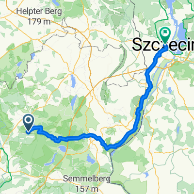 シュチェチン ルート
- Distance
- 127.2 km
- Ascent
- 596 m
- Descent
- 624 m
- Location
- Templin, Brandenburg, Germany
 Lange Radrunde vom 10. Mai 09:30
- Distance
- 85.1 km
- Ascent
- 215 m
- Descent
- 201 m
- Location
- Templin, Brandenburg, Germany
 U6 Uckermark: Lindenhof-Annenwalde-Templin
- Distance
- 30 km
- Ascent
- 164 m
- Descent
- 165 m
- Location
- Templin, Brandenburg, Germany
 Tour 2020 - Tag 1
- Distance
- 100 km
- Ascent
- 126 m
- Descent
- 150 m
- Location
- Templin, Brandenburg, Germany
Open it in the app