

2016-05-10
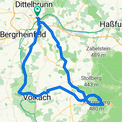
A cycling route starting in Schweinfurt, Bavaria, Germany.
Overview
About this route
Berg- und Talfahrt kurz vor dem Regen.
- -:--
- Duration
- 59.7 km
- Distance
- 366 m
- Ascent
- 366 m
- Descent
- ---
- Avg. speed
- ---
- Max. altitude
Route quality
Waytypes & surfaces along the route
Waytypes
Track
20.3 km
(34 %)
Quiet road
19.1 km
(32 %)
Surfaces
Paved
45.9 km
(77 %)
Unpaved
6 km
(10 %)
Asphalt
37.6 km
(63 %)
Paved (undefined)
6.6 km
(11 %)
Continue with Bikemap
Use, edit, or download this cycling route
You would like to ride 2016-05-10 or customize it for your own trip? Here is what you can do with this Bikemap route:
Free features
- Save this route as favorite or in collections
- Copy & plan your own version of this route
- Sync your route with Garmin or Wahoo
Premium features
Free trial for 3 days, or one-time payment. More about Bikemap Premium.
- Navigate this route on iOS & Android
- Export a GPX / KML file of this route
- Create your custom printout (try it for free)
- Download this route for offline navigation
Discover more Premium features.
Get Bikemap PremiumFrom our community
Other popular routes starting in Schweinfurt
 Schweinfurter Nordrunde
- Distance
- 36.9 km
- Ascent
- 498 m
- Descent
- 446 m
- Location
- Schweinfurt, Bavaria, Germany
 Schweinfurt-Bad Neustadt-Höchheim
- Distance
- 67.6 km
- Ascent
- 352 m
- Descent
- 320 m
- Location
- Schweinfurt, Bavaria, Germany
 All Forest, All Good
- Distance
- 47.8 km
- Ascent
- 582 m
- Descent
- 582 m
- Location
- Schweinfurt, Bavaria, Germany
 zur Ruine Aura, Wittelsbacher Turm und zurück
- Distance
- 54.7 km
- Ascent
- 707 m
- Descent
- 708 m
- Location
- Schweinfurt, Bavaria, Germany
 Radtour Schweinfurt-Stadtlauringen-Poppenhausen (58,5 km)
- Distance
- 58 km
- Ascent
- 538 m
- Descent
- 536 m
- Location
- Schweinfurt, Bavaria, Germany
 Main Radweg Schweinfurt - Schwarzach
- Distance
- 43.1 km
- Ascent
- 82 m
- Descent
- 105 m
- Location
- Schweinfurt, Bavaria, Germany
 Schweinfurter Ostkreis
- Distance
- 72.7 km
- Ascent
- 749 m
- Descent
- 716 m
- Location
- Schweinfurt, Bavaria, Germany
 SW-VK-Baumwipfelpfad-GEO
- Distance
- 86.4 km
- Ascent
- 286 m
- Descent
- 286 m
- Location
- Schweinfurt, Bavaria, Germany
Open it in the app