

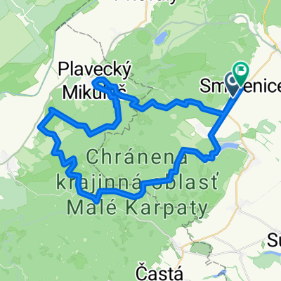
Malé Karpaty-okruh na 3h
A cycling route starting in Smolenice, Trnava Region, Slovakia.
Overview
About this route
Pohodová trasa s možnosťou odbočenia na Čiernu skalu s krásnym výhľadom.
- -:--
- Duration
- 34.4 km
- Distance
- 706 m
- Ascent
- 708 m
- Descent
- ---
- Avg. speed
- ---
- Max. altitude

Continue with Bikemap
Use, edit, or download this cycling route
You would like to ride Malé Karpaty-okruh na 3h or customize it for your own trip? Here is what you can do with this Bikemap route:
Free features
- Save this route as favorite or in collections
- Copy & plan your own version of this route
- Sync your route with Garmin or Wahoo
Premium features
Free trial for 3 days, or one-time payment. More about Bikemap Premium.
- Navigate this route on iOS & Android
- Export a GPX / KML file of this route
- Create your custom printout (try it for free)
- Download this route for offline navigation
Discover more Premium features.
Get Bikemap PremiumFrom our community
Other popular routes starting in Smolenice
 Malé Karpaty - Vápenná, Klokoč, Báborská,
- Distance
- 13.8 km
- Ascent
- 609 m
- Descent
- 609 m
- Location
- Smolenice, Trnava Region, Slovakia
 Prievaly - Šenkvice
- Distance
- 56.2 km
- Ascent
- 1,787 m
- Descent
- 1,868 m
- Location
- Smolenice, Trnava Region, Slovakia
 Jahodnícka 26, Smolenice do Jahodnícka 24, Smolenice
- Distance
- 6.3 km
- Ascent
- 147 m
- Descent
- 141 m
- Location
- Smolenice, Trnava Region, Slovakia
 Náročná
- Distance
- 48.7 km
- Ascent
- 1,358 m
- Descent
- 1,352 m
- Location
- Smolenice, Trnava Region, Slovakia
 Recording from 8. 5. 2016, 12:30
- Distance
- 25.9 km
- Ascent
- 574 m
- Descent
- 589 m
- Location
- Smolenice, Trnava Region, Slovakia
 Boleraz Bohdanovce(Dolna Krupa)
- Distance
- 29.2 km
- Ascent
- 181 m
- Descent
- 184 m
- Location
- Smolenice, Trnava Region, Slovakia
 Jahodník - Plavecký Mikuláš - Čertova skala - Jahodník.
- Distance
- 19.9 km
- Ascent
- 598 m
- Descent
- 602 m
- Location
- Smolenice, Trnava Region, Slovakia
 Jaskyňa Driny
- Distance
- 17.8 km
- Ascent
- 597 m
- Descent
- 597 m
- Location
- Smolenice, Trnava Region, Slovakia
Open it in the app