

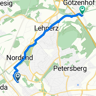
20160509_150453.gpx
A cycling route starting in Fulda, Hesse, Germany.
Overview
About this route
TEASI track
- -:--
- Duration
- 55.4 km
- Distance
- 444 m
- Ascent
- 448 m
- Descent
- ---
- Avg. speed
- ---
- Max. altitude
Continue with Bikemap
Use, edit, or download this cycling route
You would like to ride 20160509_150453.gpx or customize it for your own trip? Here is what you can do with this Bikemap route:
Free features
- Save this route as favorite or in collections
- Copy & plan your own version of this route
- Sync your route with Garmin or Wahoo
Premium features
Free trial for 3 days, or one-time payment. More about Bikemap Premium.
- Navigate this route on iOS & Android
- Export a GPX / KML file of this route
- Create your custom printout (try it for free)
- Download this route for offline navigation
Discover more Premium features.
Get Bikemap PremiumFrom our community
Other popular routes starting in Fulda
 MTB-61-Große Haube Motten
- Distance
- 69.9 km
- Ascent
- 1,350 m
- Descent
- 1,350 m
- Location
- Fulda, Hesse, Germany
 Von Fulda nach Rotenburg a.d. Fulda
- Distance
- 87 km
- Ascent
- 99 m
- Descent
- 181 m
- Location
- Fulda, Hesse, Germany
 kleine Runde Istergiesel
- Distance
- 30.5 km
- Ascent
- 265 m
- Descent
- 267 m
- Location
- Fulda, Hesse, Germany
 Bhf - Start Milseburgradweg
- Distance
- 4 km
- Ascent
- 65 m
- Descent
- 29 m
- Location
- Fulda, Hesse, Germany
 MTB-11-Rhön Special Cup 2014-Petersberg
- Distance
- 46.2 km
- Ascent
- 787 m
- Descent
- 788 m
- Location
- Fulda, Hesse, Germany
 Braunschweig - München Etappe 3
- Distance
- 129.5 km
- Ascent
- 1,213 m
- Descent
- 1,183 m
- Location
- Fulda, Hesse, Germany
 Monte Kali
- Distance
- 38.2 km
- Ascent
- 147 m
- Descent
- 147 m
- Location
- Fulda, Hesse, Germany
 Durch den Gieseler Wald
- Distance
- 26.1 km
- Ascent
- 324 m
- Descent
- 305 m
- Location
- Fulda, Hesse, Germany
Open it in the app