

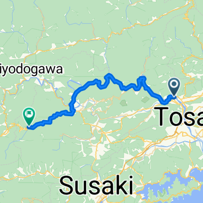
Kagami Dam - Kitayama - Homura
A cycling route starting in Ino, Kochi, Japan.
Overview
About this route
- -:--
- Duration
- 19 km
- Distance
- 669 m
- Ascent
- 673 m
- Descent
- ---
- Avg. speed
- ---
- Max. altitude
Route photos


Continue with Bikemap
Use, edit, or download this cycling route
You would like to ride Kagami Dam - Kitayama - Homura or customize it for your own trip? Here is what you can do with this Bikemap route:
Free features
- Save this route as favorite or in collections
- Copy & plan your own version of this route
- Sync your route with Garmin or Wahoo
Premium features
Free trial for 3 days, or one-time payment. More about Bikemap Premium.
- Navigate this route on iOS & Android
- Export a GPX / KML file of this route
- Create your custom printout (try it for free)
- Download this route for offline navigation
Discover more Premium features.
Get Bikemap PremiumFrom our community
Other popular routes starting in Ino
 Kagami Dam - Kitayama - Homura
- Distance
- 19 km
- Ascent
- 669 m
- Descent
- 673 m
- Location
- Ino, Kochi, Japan
 枝川駅, いの町 to 2276−2, いの町
- Distance
- 100.1 km
- Ascent
- 852 m
- Descent
- 857 m
- Location
- Ino, Kochi, Japan
 Shikoku
- Distance
- 714 km
- Ascent
- 1,731 m
- Descent
- 1,746 m
- Location
- Ino, Kochi, Japan
 Shingunomori - Mitani - Kagami Dam
- Distance
- 34.9 km
- Ascent
- 1,081 m
- Descent
- 1,081 m
- Location
- Ino, Kochi, Japan
 shikoku ochi- kochi
- Distance
- 38.9 km
- Ascent
- 432 m
- Descent
- 216 m
- Location
- Ino, Kochi, Japan
 Shingunomori Koen-Amigaws - Kagami Dam - Soan temple
- Distance
- 30.2 km
- Ascent
- 910 m
- Descent
- 910 m
- Location
- Ino, Kochi, Japan
 平和の滝
平和の滝- Distance
- 24.5 km
- Ascent
- 829 m
- Descent
- 829 m
- Location
- Ino, Kochi, Japan
 ride through Kochi
- Distance
- 23 km
- Ascent
- 1,103 m
- Descent
- 1,182 m
- Location
- Ino, Kochi, Japan
Open it in the app