

vía verde día 5
A cycling route starting in Alcocer de Planes, Valencia, Spain.
Overview
About this route
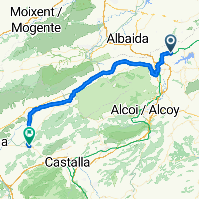
return route from Gaianes to Denia
- -:--
- Duration
- 65.2 km
- Distance
- 93 m
- Ascent
- 511 m
- Descent
- ---
- Avg. speed
- ---
- Max. altitude
Route quality
Waytypes & surfaces along the route
Waytypes
Quiet road
18.9 km
(29 %)
Road
13.7 km
(21 %)
Surfaces
Paved
11.1 km
(17 %)
Unpaved
12.4 km
(19 %)
Gravel
12.4 km
(19 %)
Asphalt
8.5 km
(13 %)
Continue with Bikemap
Use, edit, or download this cycling route
You would like to ride vía verde día 5 or customize it for your own trip? Here is what you can do with this Bikemap route:
Free features
- Save this route as favorite or in collections
- Copy & plan your own version of this route
- Sync your route with Garmin or Wahoo
Premium features
Free trial for 3 days, or one-time payment. More about Bikemap Premium.
- Navigate this route on iOS & Android
- Export a GPX / KML file of this route
- Create your custom printout (try it for free)
- Download this route for offline navigation
Discover more Premium features.
Get Bikemap PremiumFrom our community
Other popular routes starting in Alcocer de Planes
 vía verde día 5
- Distance
- 65.2 km
- Ascent
- 93 m
- Descent
- 511 m
- Location
- Alcocer de Planes, Valencia, Spain
 gaianes-biar
- Distance
- 49.6 km
- Ascent
- 542 m
- Descent
- 271 m
- Location
- Alcocer de Planes, Valencia, Spain
 Galanes biar
- Distance
- 48.5 km
- Ascent
- 511 m
- Descent
- 194 m
- Location
- Alcocer de Planes, Valencia, Spain
 El Comtat a peu: de Gaianes al refugi el Penitent i a l'albufera
- Distance
- 10.7 km
- Ascent
- 344 m
- Descent
- 347 m
- Location
- Alcocer de Planes, Valencia, Spain
 alcocer-alcocer-3-7-2016
- Distance
- 53 km
- Ascent
- 948 m
- Descent
- 951 m
- Location
- Alcocer de Planes, Valencia, Spain
 ruta vía verde día 2
- Distance
- 47.8 km
- Ascent
- 549 m
- Descent
- 263 m
- Location
- Alcocer de Planes, Valencia, Spain
 Gallanes-Denia
- Distance
- 69.9 km
- Ascent
- 925 m
- Descent
- 1,331 m
- Location
- Alcocer de Planes, Valencia, Spain
 gaianes-denia
- Distance
- 60.7 km
- Ascent
- 301 m
- Descent
- 717 m
- Location
- Alcocer de Planes, Valencia, Spain
Open it in the app