

Siglisdorfer-Islisberg
A cycling route starting in Zürich (Kreis 9) / Albisrieden, Canton of Zurich, Switzerland.
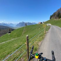
Overview
About this route
- -:--
- Duration
- 119.2 km
- Distance
- 1,335 m
- Ascent
- 1,339 m
- Descent
- ---
- Avg. speed
- ---
- Max. altitude

Route quality
Waytypes & surfaces along the route
Waytypes
Road
47.7 km
(40 %)
Quiet road
25 km
(21 %)
Surfaces
Paved
92.9 km
(78 %)
Unpaved
2.4 km
(2 %)
Asphalt
91.7 km
(77 %)
Paved (undefined)
1.2 km
(1 %)
Continue with Bikemap
Use, edit, or download this cycling route
You would like to ride Siglisdorfer-Islisberg or customize it for your own trip? Here is what you can do with this Bikemap route:
Free features
- Save this route as favorite or in collections
- Copy & plan your own version of this route
- Split it into stages to create a multi-day tour
- Sync your route with Garmin or Wahoo
Premium features
Free trial for 3 days, or one-time payment. More about Bikemap Premium.
- Navigate this route on iOS & Android
- Export a GPX / KML file of this route
- Create your custom printout (try it for free)
- Download this route for offline navigation
Discover more Premium features.
Get Bikemap PremiumFrom our community
Other popular routes starting in Zürich (Kreis 9) / Albisrieden
 Türlersee Runde
- Distance
- 52.1 km
- Ascent
- 413 m
- Descent
- 439 m
- Location
- Zürich (Kreis 9) / Albisrieden, Canton of Zurich, Switzerland
 Bremgarten
- Distance
- 41 km
- Ascent
- 682 m
- Descent
- 679 m
- Location
- Zürich (Kreis 9) / Albisrieden, Canton of Zurich, Switzerland
 Mutschellen pass
- Distance
- 38.2 km
- Ascent
- 572 m
- Descent
- 572 m
- Location
- Zürich (Kreis 9) / Albisrieden, Canton of Zurich, Switzerland
 Fünf Pässe Tour Zürich
- Distance
- 56.8 km
- Ascent
- 746 m
- Descent
- 744 m
- Location
- Zürich (Kreis 9) / Albisrieden, Canton of Zurich, Switzerland
 Zürich-Aegerisee-Sattel-Biberbrugg-Hirzel-Sihltal-Zürich
- Distance
- 101.6 km
- Ascent
- 1,288 m
- Descent
- 1,273 m
- Location
- Zürich (Kreis 9) / Albisrieden, Canton of Zurich, Switzerland
 Ibergeregg pass
- Distance
- 133.3 km
- Ascent
- 1,543 m
- Descent
- 1,543 m
- Location
- Zürich (Kreis 9) / Albisrieden, Canton of Zurich, Switzerland
 Albisrieden-Schlieren-Urdorf-Uitikon
- Distance
- 18 km
- Ascent
- 289 m
- Descent
- 291 m
- Location
- Zürich (Kreis 9) / Albisrieden, Canton of Zurich, Switzerland
 züri-albisrieden - hirzel - wädenswil
- Distance
- 63 km
- Ascent
- 708 m
- Descent
- 708 m
- Location
- Zürich (Kreis 9) / Albisrieden, Canton of Zurich, Switzerland
Open it in the app