

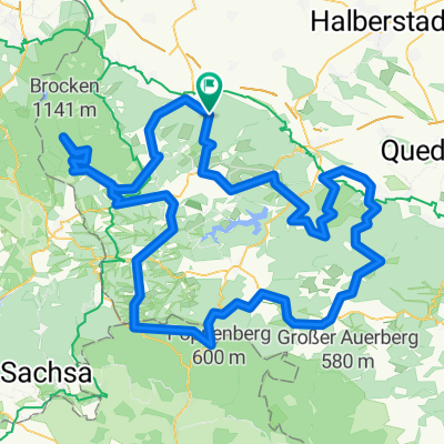
WR 38km / 470 Hm - flach rein
A cycling route starting in Wernigerode, Saxony-Anhalt, Germany.
Overview
About this route
WR- Benzigerode - Helmburg - Elbingerode - Drei Annen - WR
- -:--
- Duration
- 38 km
- Distance
- 496 m
- Ascent
- 492 m
- Descent
- ---
- Avg. speed
- ---
- Max. altitude
Route quality
Waytypes & surfaces along the route
Waytypes
Road
12.9 km
(34 %)
Quiet road
5.3 km
(14 %)
Surfaces
Paved
30.7 km
(81 %)
Asphalt
30.7 km
(81 %)
Undefined
7.2 km
(19 %)
Continue with Bikemap
Use, edit, or download this cycling route
You would like to ride WR 38km / 470 Hm - flach rein or customize it for your own trip? Here is what you can do with this Bikemap route:
Free features
- Save this route as favorite or in collections
- Copy & plan your own version of this route
- Sync your route with Garmin or Wahoo
Premium features
Free trial for 3 days, or one-time payment. More about Bikemap Premium.
- Navigate this route on iOS & Android
- Export a GPX / KML file of this route
- Create your custom printout (try it for free)
- Download this route for offline navigation
Discover more Premium features.
Get Bikemap PremiumFrom our community
Other popular routes starting in Wernigerode
 Wurmberg
- Distance
- 57.2 km
- Ascent
- 1,056 m
- Descent
- 916 m
- Location
- Wernigerode, Saxony-Anhalt, Germany
 Wernigerode - Brocken - Bad Harzburg - Wernigerode
- Distance
- 91.4 km
- Ascent
- 1,313 m
- Descent
- 1,313 m
- Location
- Wernigerode, Saxony-Anhalt, Germany
 Wernigerode HarzW-126km (RK)
- Distance
- 125.4 km
- Ascent
- 1,866 m
- Descent
- 1,550 m
- Location
- Wernigerode, Saxony-Anhalt, Germany
 Wernigerode HarzW-134km (RK) Königsetappe
- Distance
- 133.8 km
- Ascent
- 1,425 m
- Descent
- 1,425 m
- Location
- Wernigerode, Saxony-Anhalt, Germany
 Große Dammstraße 32, Wernigerode nach Große Dammstraße 32, Wernigerode
- Distance
- 16.5 km
- Ascent
- 16 m
- Descent
- 7 m
- Location
- Wernigerode, Saxony-Anhalt, Germany
 Friedrich-Naumann-Straße 46, Wernigerode nach Friedrich-Naumann-Straße 46, Wernigerode
- Distance
- 45.4 km
- Ascent
- 460 m
- Descent
- 458 m
- Location
- Wernigerode, Saxony-Anhalt, Germany
 Wernigerode -> Walkenried -> Thale Hbf.
- Distance
- 94.4 km
- Ascent
- 1,169 m
- Descent
- 1,017 m
- Location
- Wernigerode, Saxony-Anhalt, Germany
 Brockenrunde
- Distance
- 153 km
- Ascent
- 2,210 m
- Descent
- 2,116 m
- Location
- Wernigerode, Saxony-Anhalt, Germany
Open it in the app