Rundtour Hannover und Dörfer
A cycling route starting in Pattensen, Lower Saxony, Germany.
Overview
About this route
Bissel outside of Hanover through the villages
- -:--
- Duration
- 115.2 km
- Distance
- 162 m
- Ascent
- 162 m
- Descent
- ---
- Avg. speed
- ---
- Max. altitude
Route quality
Waytypes & surfaces along the route
Waytypes
Path
38 km
(33 %)
Road
15 km
(13 %)
Surfaces
Paved
85.2 km
(74 %)
Unpaved
6.9 km
(6 %)
Asphalt
64.5 km
(56 %)
Concrete
12.7 km
(11 %)
Continue with Bikemap
Use, edit, or download this cycling route
You would like to ride Rundtour Hannover und Dörfer or customize it for your own trip? Here is what you can do with this Bikemap route:
Free features
- Save this route as favorite or in collections
- Copy & plan your own version of this route
- Split it into stages to create a multi-day tour
- Sync your route with Garmin or Wahoo
Premium features
Free trial for 3 days, or one-time payment. More about Bikemap Premium.
- Navigate this route on iOS & Android
- Export a GPX / KML file of this route
- Create your custom printout (try it for free)
- Download this route for offline navigation
Discover more Premium features.
Get Bikemap PremiumFrom our community
Other popular routes starting in Pattensen
Langsame Fahrt Koldingen, Giften- Distance
- 22.6 km
- Ascent
- 3 m
- Descent
- 0 m
- Location
- Pattensen, Lower Saxony, Germany
Mit Nati nach Neue Straße 25, 31036 Eime- Distance
- 17.9 km
- Ascent
- 76 m
- Descent
- 85 m
- Location
- Pattensen, Lower Saxony, Germany
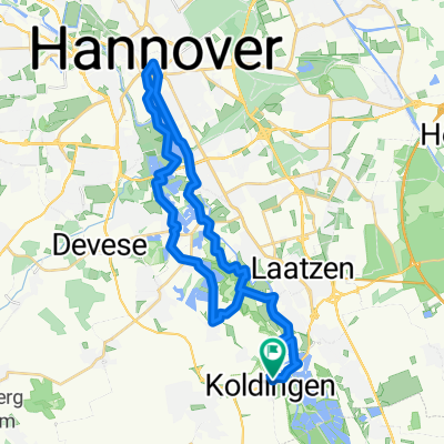
Koldingen - Hannover 35km- Distance
- 34.3 km
- Ascent
- 14 m
- Descent
- 14 m
- Location
- Pattensen, Lower Saxony, Germany
Von Pattensen bis Hannover- Distance
- 21.5 km
- Ascent
- 42 m
- Descent
- 58 m
- Location
- Pattensen, Lower Saxony, Germany
Koldinger Teich 1- Distance
- 20.5 km
- Ascent
- 25 m
- Descent
- 25 m
- Location
- Pattensen, Lower Saxony, Germany
Mittelstraße, Springe nach Mittelstraße, Springe- Distance
- 52.6 km
- Ascent
- 90 m
- Descent
- 89 m
- Location
- Pattensen, Lower Saxony, Germany
RTF Pattensen 2010 - 115 km- Distance
- 104.9 km
- Ascent
- 634 m
- Descent
- 631 m
- Location
- Pattensen, Lower Saxony, Germany
Leinemasch 16 km Strecke- Distance
- 15.9 km
- Ascent
- 19 m
- Descent
- 22 m
- Location
- Pattensen, Lower Saxony, Germany
Open it in the app


