
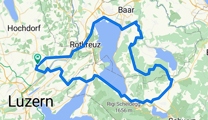
Rond-Zugersee-83km-1330hoogte
A cycling route starting in Buchrain, Canton of Lucerne, Switzerland.
Overview
About this route
- -:--
- Duration
- 83.3 km
- Distance
- 1,164 m
- Ascent
- 1,170 m
- Descent
- ---
- Avg. speed
- ---
- Max. altitude
Route quality
Waytypes & surfaces along the route
Waytypes
Quiet road
26.7 km
(32 %)
Road
7.5 km
(9 %)
Surfaces
Paved
57.5 km
(69 %)
Unpaved
1.7 km
(2 %)
Asphalt
55 km
(66 %)
Paved (undefined)
2.5 km
(3 %)
Continue with Bikemap
Use, edit, or download this cycling route
You would like to ride Rond-Zugersee-83km-1330hoogte or customize it for your own trip? Here is what you can do with this Bikemap route:
Free features
- Save this route as favorite or in collections
- Copy & plan your own version of this route
- Split it into stages to create a multi-day tour
- Sync your route with Garmin or Wahoo
Premium features
Free trial for 3 days, or one-time payment. More about Bikemap Premium.
- Navigate this route on iOS & Android
- Export a GPX / KML file of this route
- Create your custom printout (try it for free)
- Download this route for offline navigation
Discover more Premium features.
Get Bikemap PremiumFrom our community
Other popular routes starting in Buchrain
 Buchrain - Michelskreuz - Honau - Reuss - Buchrain
- Distance
- 21.4 km
- Ascent
- 393 m
- Descent
- 393 m
- Location
- Buchrain, Canton of Lucerne, Switzerland
 Seebodenalp
- Distance
- 40.3 km
- Ascent
- 932 m
- Descent
- 932 m
- Location
- Buchrain, Canton of Lucerne, Switzerland
 Michelskreuz 2 Trails
- Distance
- 28.5 km
- Ascent
- 701 m
- Descent
- 707 m
- Location
- Buchrain, Canton of Lucerne, Switzerland
 Buchrain - Winterhalden - Sins - Gisikon
- Distance
- 28.3 km
- Ascent
- 239 m
- Descent
- 285 m
- Location
- Buchrain, Canton of Lucerne, Switzerland
 Rond-Zugersee-83km-1330hoogte
- Distance
- 83.3 km
- Ascent
- 1,164 m
- Descent
- 1,170 m
- Location
- Buchrain, Canton of Lucerne, Switzerland
 J Buchrain-Bremgarten
- Distance
- 38.1 km
- Ascent
- 181 m
- Descent
- 214 m
- Location
- Buchrain, Canton of Lucerne, Switzerland
 Zugerbergtour
- Distance
- 61.1 km
- Ascent
- 979 m
- Descent
- 979 m
- Location
- Buchrain, Canton of Lucerne, Switzerland
 Buchrain - Emmen- kleine Emme - Buchrain
- Distance
- 45.9 km
- Ascent
- 352 m
- Descent
- 358 m
- Location
- Buchrain, Canton of Lucerne, Switzerland
Open it in the app