

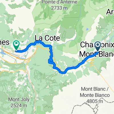
Ultimate Étapes, Stage 15: Cycling's Greatest Climb
A cycling route starting in Chamonix, Auvergne-Rhône-Alpes, France.
Overview
About this route
Ultimate Étapes, Stage 15: Cycling's Greatest Climb
- -:--
- Duration
- 200.5 km
- Distance
- 4,571 m
- Ascent
- 3,759 m
- Descent
- ---
- Avg. speed
- ---
- Max. altitude
Route quality
Waytypes & surfaces along the route
Waytypes
Quiet road
42.1 km
(21 %)
Road
26.1 km
(13 %)
Surfaces
Paved
110.3 km
(55 %)
Unpaved
4 km
(2 %)
Asphalt
110.3 km
(55 %)
Gravel
4 km
(2 %)
Undefined
86.2 km
(43 %)
Continue with Bikemap
Use, edit, or download this cycling route
You would like to ride Ultimate Étapes, Stage 15: Cycling's Greatest Climb or customize it for your own trip? Here is what you can do with this Bikemap route:
Free features
- Save this route as favorite or in collections
- Copy & plan your own version of this route
- Split it into stages to create a multi-day tour
- Sync your route with Garmin or Wahoo
Premium features
Free trial for 3 days, or one-time payment. More about Bikemap Premium.
- Navigate this route on iOS & Android
- Export a GPX / KML file of this route
- Create your custom printout (try it for free)
- Download this route for offline navigation
Discover more Premium features.
Get Bikemap PremiumFrom our community
Other popular routes starting in Chamonix
 139 Route des Drus, Chamonix to 24 Chemin des Murailles, Chamonix
- Distance
- 28.8 km
- Ascent
- 653 m
- Descent
- 1,706 m
- Location
- Chamonix, Auvergne-Rhône-Alpes, France
 Chamonix - Finhaut
- Distance
- 52.8 km
- Ascent
- 1,571 m
- Descent
- 1,571 m
- Location
- Chamonix, Auvergne-Rhône-Alpes, France
 Chemin des Snions, Chamonix to Avenue Michel Croz, Chamonix
- Distance
- 11.6 km
- Ascent
- 239 m
- Descent
- 226 m
- Location
- Chamonix, Auvergne-Rhône-Alpes, France
 Barrage d'Emosson
- Distance
- 63.4 km
- Ascent
- 1,663 m
- Descent
- 1,664 m
- Location
- Chamonix, Auvergne-Rhône-Alpes, France
 Avenue Michel Croz, Chamonix to Chemin Gabriel Loppé, Chamonix
- Distance
- 24.6 km
- Ascent
- 458 m
- Descent
- 456 m
- Location
- Chamonix, Auvergne-Rhône-Alpes, France
 chamonix to passy and back
- Distance
- 24.9 km
- Ascent
- 487 m
- Descent
- 836 m
- Location
- Chamonix, Auvergne-Rhône-Alpes, France
 Col de Balme, Col des Posettes Loop
- Distance
- 49.8 km
- Ascent
- 1,411 m
- Descent
- 1,413 m
- Location
- Chamonix, Auvergne-Rhône-Alpes, France
 Tour de Mont Blanc
- Distance
- 119.2 km
- Ascent
- 7,716 m
- Descent
- 7,175 m
- Location
- Chamonix, Auvergne-Rhône-Alpes, France
Open it in the app