

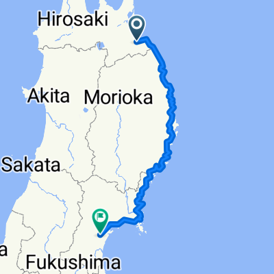
Hachinohe City to Chitose City (via the Silver Ferry, Japan)
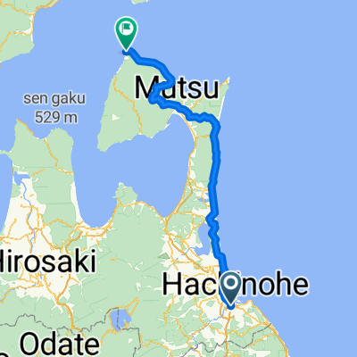
A cycling route starting in Uchimaru, Aomori, Japan.
Overview
About this route
- -:--
- Duration
- 267.8 km
- Distance
- 21 m
- Ascent
- 13 m
- Descent
- ---
- Avg. speed
- ---
- Max. altitude

Continue with Bikemap
Use, edit, or download this cycling route
You would like to ride Hachinohe City to Chitose City (via the Silver Ferry, Japan) or customize it for your own trip? Here is what you can do with this Bikemap route:
Free features
- Save this route as favorite or in collections
- Copy & plan your own version of this route
- Split it into stages to create a multi-day tour
- Sync your route with Garmin or Wahoo
Premium features
Free trial for 3 days, or one-time payment. More about Bikemap Premium.
- Navigate this route on iOS & Android
- Export a GPX / KML file of this route
- Create your custom printout (try it for free)
- Download this route for offline navigation
Discover more Premium features.
Get Bikemap PremiumFrom our community
Other popular routes starting in Uchimaru
 JT E13
- Distance
- 166.9 km
- Ascent
- 2,498 m
- Descent
- 1,261 m
- Location
- Uchimaru, Aomori, Japan
 Hachinohe to Sendai
- Distance
- 557.5 km
- Ascent
- 1,376 m
- Descent
- 1,340 m
- Location
- Uchimaru, Aomori, Japan
 hatinohe-oma
- Distance
- 183.9 km
- Ascent
- 932 m
- Descent
- 911 m
- Location
- Uchimaru, Aomori, Japan
 久保, 八戸市 to 柳町, 八戸市
- Distance
- 44.7 km
- Ascent
- 456 m
- Descent
- 463 m
- Location
- Uchimaru, Aomori, Japan
 Numadate 4-Chōme, Hachinohe to Sozenhigashi 2-Chōme, Hashikami
- Distance
- 11.4 km
- Ascent
- 114 m
- Descent
- 6 m
- Location
- Uchimaru, Aomori, Japan
 Oirase
- Distance
- 187.1 km
- Ascent
- 1,426 m
- Descent
- 1,438 m
- Location
- Uchimaru, Aomori, Japan
 Japan bike route part 2
- Distance
- 1,392.9 km
- Ascent
- 3,358 m
- Descent
- 3,356 m
- Location
- Uchimaru, Aomori, Japan
 hatinohe o-ma
- Distance
- 179.9 km
- Ascent
- 781 m
- Descent
- 769 m
- Location
- Uchimaru, Aomori, Japan
Open it in the app