

M.SL - kalety - kol.woznicka+
A cycling route starting in Miasteczko Śląskie, Silesian Voivodeship, Poland.
Overview
About this route
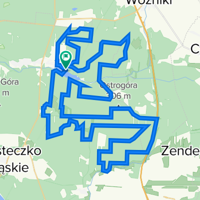
Parking at the beginning by the waterworks.
It starts straight, then there's a sand hill, then a ladybug and picnic spots by the pond.
- -:--
- Duration
- 26.7 km
- Distance
- 84 m
- Ascent
- 83 m
- Descent
- ---
- Avg. speed
- ---
- Max. altitude

Route quality
Waytypes & surfaces along the route
Waytypes
Track
17.1 km
(64 %)
Quiet road
5.3 km
(20 %)
Surfaces
Paved
2.7 km
(10 %)
Unpaved
11.8 km
(44 %)
Gravel
5.9 km
(22 %)
Ground
5.1 km
(19 %)
Route highlights
Points of interest along the route
Point of interest after 7.4 km
Biedronka
Point of interest after 8.5 km
PIKNIK
Continue with Bikemap
Use, edit, or download this cycling route
You would like to ride M.SL - kalety - kol.woznicka+ or customize it for your own trip? Here is what you can do with this Bikemap route:
Free features
- Save this route as favorite or in collections
- Copy & plan your own version of this route
- Sync your route with Garmin or Wahoo
Premium features
Free trial for 3 days, or one-time payment. More about Bikemap Premium.
- Navigate this route on iOS & Android
- Export a GPX / KML file of this route
- Create your custom printout (try it for free)
- Download this route for offline navigation
Discover more Premium features.
Get Bikemap PremiumFrom our community
Other popular routes starting in Miasteczko Śląskie
 Miasteczko Slaskie-Kalety-Koszecin-Kokotek-Brynek
- Distance
- 66.6 km
- Ascent
- 177 m
- Descent
- 177 m
- Location
- Miasteczko Śląskie, Silesian Voivodeship, Poland
 Kalety do 30-lecia 106, Kalety
- Distance
- 17.7 km
- Ascent
- 226 m
- Descent
- 226 m
- Location
- Miasteczko Śląskie, Silesian Voivodeship, Poland
 "Zielona" - do Woźnik
- Distance
- 25.3 km
- Ascent
- 114 m
- Descent
- 112 m
- Location
- Miasteczko Śląskie, Silesian Voivodeship, Poland
 M.SL - kalety - kol.woznicka+
- Distance
- 26.7 km
- Ascent
- 84 m
- Descent
- 83 m
- Location
- Miasteczko Śląskie, Silesian Voivodeship, Poland
 Mało Leśno Rajza
- Distance
- 62.9 km
- Ascent
- 176 m
- Descent
- 175 m
- Location
- Miasteczko Śląskie, Silesian Voivodeship, Poland
 Zalew Nakło Chechło
- Distance
- 9.6 km
- Ascent
- 35 m
- Descent
- 36 m
- Location
- Miasteczko Śląskie, Silesian Voivodeship, Poland
 Mega Miasteczko
- Distance
- 29 km
- Ascent
- 169 m
- Descent
- 188 m
- Location
- Miasteczko Śląskie, Silesian Voivodeship, Poland
 Kaleckie szutry
- Distance
- 66.1 km
- Ascent
- 115 m
- Descent
- 116 m
- Location
- Miasteczko Śląskie, Silesian Voivodeship, Poland
Open it in the app