

Fluggaenkoecchicebolsen - rowerowy rajd majówkowy
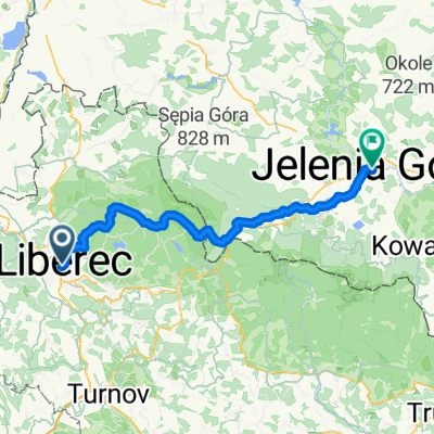
A cycling route starting in Liberec, Liberecký kraj, Czechia.
Overview
About this route
26.05
- -:--
- Duration
- 180.5 km
- Distance
- 345 m
- Ascent
- 584 m
- Descent
- ---
- Avg. speed
- ---
- Max. altitude

Route quality
Waytypes & surfaces along the route
Waytypes
Quiet road
65 km
(36 %)
Road
27.1 km
(15 %)
Surfaces
Paved
110.1 km
(61 %)
Unpaved
16.2 km
(9 %)
Asphalt
102.9 km
(57 %)
Gravel
10.8 km
(6 %)
Route highlights
Points of interest along the route

Photo after 29.4 km

Photo after 104.5 km

Photo after 174.3 km
Continue with Bikemap
Use, edit, or download this cycling route
You would like to ride Fluggaenkoecchicebolsen - rowerowy rajd majówkowy or customize it for your own trip? Here is what you can do with this Bikemap route:
Free features
- Save this route as favorite or in collections
- Copy & plan your own version of this route
- Split it into stages to create a multi-day tour
- Sync your route with Garmin or Wahoo
Premium features
Free trial for 3 days, or one-time payment. More about Bikemap Premium.
- Navigate this route on iOS & Android
- Export a GPX / KML file of this route
- Create your custom printout (try it for free)
- Download this route for offline navigation
Discover more Premium features.
Get Bikemap PremiumFrom our community
Other popular routes starting in Liberec
 Nástřel trasy na DETOX jízdu po Hobludí rozlučce
- Distance
- 42.8 km
- Ascent
- 1,143 m
- Descent
- 1,208 m
- Location
- Liberec, Liberecký kraj, Czechia
 Lbc-Vysoké n/J. - Harrachov-Szklarska Poreba-N.Město - Lbc
- Distance
- 137.5 km
- Ascent
- 2,254 m
- Descent
- 2,263 m
- Location
- Liberec, Liberecký kraj, Czechia
 Fluggaenkoecchicebolsen - rowerowy rajd majówkowy
- Distance
- 180.5 km
- Ascent
- 345 m
- Descent
- 584 m
- Location
- Liberec, Liberecký kraj, Czechia
 Perštýn-Jeřmanice
- Distance
- 9.1 km
- Ascent
- 264 m
- Descent
- 167 m
- Location
- Liberec, Liberecký kraj, Czechia
 Liberec - Jelenia Góra
- Distance
- 72.2 km
- Ascent
- 1,123 m
- Descent
- 1,155 m
- Location
- Liberec, Liberecký kraj, Czechia
 Vratislavice - Pilínkov - Panský lom - Pláně - Obří sud
- Distance
- 29.7 km
- Ascent
- 643 m
- Descent
- 643 m
- Location
- Liberec, Liberecký kraj, Czechia
 28.9.2011 MTB Lbc - Kryštofák - Ještědka - Pláně - Lbc
- Distance
- 35.8 km
- Ascent
- 769 m
- Descent
- 775 m
- Location
- Liberec, Liberecký kraj, Czechia
 30.9.2011 MTB Lbc _ Frýdlant
- Distance
- 33.3 km
- Ascent
- 422 m
- Descent
- 543 m
- Location
- Liberec, Liberecký kraj, Czechia
Open it in the app