

Polževo MTB
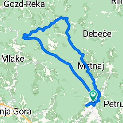
A cycling route starting in Ivančna Gorica, Občina Ivančna Gorica, Slovenia.
Overview
About this route
Moderate difficulty MTB route. Paved, gravel and singletracks, tricky downhill section at very end.
- -:--
- Duration
- 19.6 km
- Distance
- 475 m
- Ascent
- 476 m
- Descent
- ---
- Avg. speed
- ---
- Max. altitude

Continue with Bikemap
Use, edit, or download this cycling route
You would like to ride Polževo MTB or customize it for your own trip? Here is what you can do with this Bikemap route:
Free features
- Save this route as favorite or in collections
- Copy & plan your own version of this route
- Sync your route with Garmin or Wahoo
Premium features
Free trial for 3 days, or one-time payment. More about Bikemap Premium.
- Navigate this route on iOS & Android
- Export a GPX / KML file of this route
- Create your custom printout (try it for free)
- Download this route for offline navigation
Discover more Premium features.
Get Bikemap PremiumFrom our community
Other popular routes starting in Ivančna Gorica
 gabrje - obolno - sela - gabrje
- Distance
- 18.4 km
- Ascent
- 488 m
- Descent
- 488 m
- Location
- Ivančna Gorica, Občina Ivančna Gorica, Slovenia
 Krog Polževo
- Distance
- 23.5 km
- Ascent
- 379 m
- Descent
- 379 m
- Location
- Ivančna Gorica, Občina Ivančna Gorica, Slovenia
 VG-Kurešček-VG
- Distance
- 79.4 km
- Ascent
- 783 m
- Descent
- 778 m
- Location
- Ivančna Gorica, Občina Ivančna Gorica, Slovenia
 Z MOTORJEM NAOKOLI
- Distance
- 375.3 km
- Ascent
- 6,643 m
- Descent
- 6,553 m
- Location
- Ivančna Gorica, Občina Ivančna Gorica, Slovenia
 HisaIDAslapovi
- Distance
- 28 km
- Ascent
- 554 m
- Descent
- 555 m
- Location
- Ivančna Gorica, Občina Ivančna Gorica, Slovenia
 Žuži - trebnje - (stranske ceste) hrastov dol
- Distance
- 57.6 km
- Ascent
- 440 m
- Descent
- 440 m
- Location
- Ivančna Gorica, Občina Ivančna Gorica, Slovenia
 Polževo MTB
- Distance
- 19.6 km
- Ascent
- 475 m
- Descent
- 476 m
- Location
- Ivančna Gorica, Občina Ivančna Gorica, Slovenia
 obolno
- Distance
- 17.2 km
- Ascent
- 498 m
- Descent
- 498 m
- Location
- Ivančna Gorica, Občina Ivančna Gorica, Slovenia
Open it in the app