
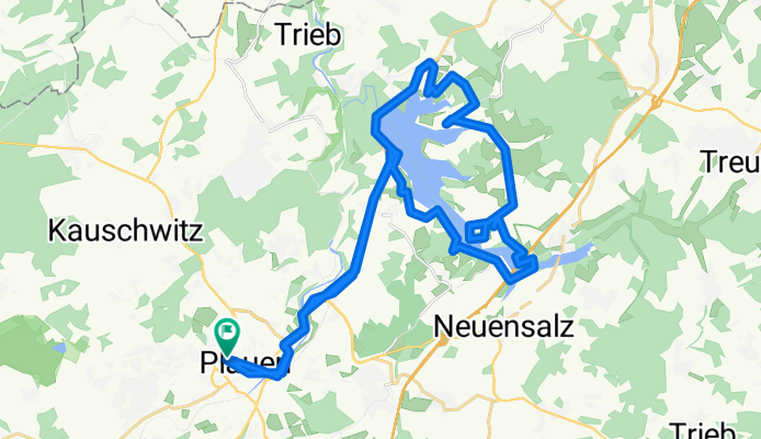
Plauen und rund um Talsperre Pöhl
A cycling route starting in Plauen, Saxony, Germany.
Overview
About this route
- -:--
- Duration
- 39.9 km
- Distance
- 358 m
- Ascent
- 355 m
- Descent
- ---
- Avg. speed
- ---
- Max. altitude

Continue with Bikemap
Use, edit, or download this cycling route
You would like to ride Plauen und rund um Talsperre Pöhl or customize it for your own trip? Here is what you can do with this Bikemap route:
Free features
- Save this route as favorite or in collections
- Copy & plan your own version of this route
- Sync your route with Garmin or Wahoo
Premium features
Free trial for 3 days, or one-time payment. More about Bikemap Premium.
- Navigate this route on iOS & Android
- Export a GPX / KML file of this route
- Create your custom printout (try it for free)
- Download this route for offline navigation
Discover more Premium features.
Get Bikemap PremiumFrom our community
Other popular routes starting in Plauen
 Von Plauen bis Weischlitz
- Distance
- 13.1 km
- Ascent
- 214 m
- Descent
- 148 m
- Location
- Plauen, Saxony, Germany
 Plauen-Schöneck und zurück
- Distance
- 68.3 km
- Ascent
- 815 m
- Descent
- 815 m
- Location
- Plauen, Saxony, Germany
 Abendliche Entspannungsrunde
- Distance
- 23.7 km
- Ascent
- 245 m
- Descent
- 255 m
- Location
- Plauen, Saxony, Germany
 Elsterradweg Plauen-Kürbitz
- Distance
- 8.9 km
- Ascent
- 47 m
- Descent
- 29 m
- Location
- Plauen, Saxony, Germany
 Radtour der Stdtagalerie Plauen 2012
- Distance
- 44.9 km
- Ascent
- 532 m
- Descent
- 532 m
- Location
- Plauen, Saxony, Germany
 Schulstraße 14, Plauen nach Schulstraße 14, Plauen
- Distance
- 14.6 km
- Ascent
- 305 m
- Descent
- 305 m
- Location
- Plauen, Saxony, Germany
 Plauen und rund um Talsperre Pöhl
- Distance
- 39.9 km
- Ascent
- 358 m
- Descent
- 355 m
- Location
- Plauen, Saxony, Germany
 Elster Runde
- Distance
- 24.6 km
- Ascent
- 244 m
- Descent
- 259 m
- Location
- Plauen, Saxony, Germany
Open it in the app