

Long ride from 22. мај 11.19.
A cycling route starting in Hranice, Karlovarský kraj, Czechia.
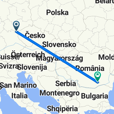
Overview
About this route
Uvac Rudo
- 3 h 20 min
- Duration
- 960.4 km
- Distance
- 4,643 m
- Ascent
- 4,876 m
- Descent
- 287.6 km/h
- Avg. speed
- ---
- Max. altitude

Route photos


Continue with Bikemap
Use, edit, or download this cycling route
You would like to ride Long ride from 22. мај 11.19. or customize it for your own trip? Here is what you can do with this Bikemap route:
Free features
- Save this route as favorite or in collections
- Copy & plan your own version of this route
- Split it into stages to create a multi-day tour
- Sync your route with Garmin or Wahoo
Premium features
Free trial for 3 days, or one-time payment. More about Bikemap Premium.
- Navigate this route on iOS & Android
- Export a GPX / KML file of this route
- Create your custom printout (try it for free)
- Download this route for offline navigation
Discover more Premium features.
Get Bikemap PremiumFrom our community
Other popular routes starting in Hranice
 Brief bike tour from 27 November, 15:57
- Distance
- 923.8 km
- Ascent
- 1,093 m
- Descent
- 1,662 m
- Location
- Hranice, Karlovarský kraj, Czechia
 Svoge.Batolia.Osegovo.Leskovdol.Svoge
- Distance
- 1,237.3 km
- Ascent
- 5,279 m
- Descent
- 5,451 m
- Location
- Hranice, Karlovarský kraj, Czechia
 Aufnahme vom 19. September 12:54
- Distance
- 240.3 km
- Ascent
- 1,699 m
- Descent
- 2,215 m
- Location
- Hranice, Karlovarský kraj, Czechia
 rutá 17 marzo _ 1
- Distance
- 11,731.5 km
- Ascent
- 4,140 m
- Descent
- 4,749 m
- Location
- Hranice, Karlovarský kraj, Czechia
 Recording from 17:44, 18 iulie
- Distance
- 1,240.1 km
- Ascent
- 3,297 m
- Descent
- 3,841 m
- Location
- Hranice, Karlovarský kraj, Czechia
 Heilbronn - Bad Rappenau - Neckarmühlbach - Heilbronn
- Distance
- 312.4 km
- Ascent
- 1,143 m
- Descent
- 1,606 m
- Location
- Hranice, Karlovarský kraj, Czechia
 Karaka Point
- Distance
- 18,332.7 km
- Ascent
- 3,670 m
- Descent
- 4,281 m
- Location
- Hranice, Karlovarský kraj, Czechia
 Recording from 6:42, 2 septembrie
- Distance
- 1,075.6 km
- Ascent
- 2,906 m
- Descent
- 3,161 m
- Location
- Hranice, Karlovarský kraj, Czechia
Open it in the app