
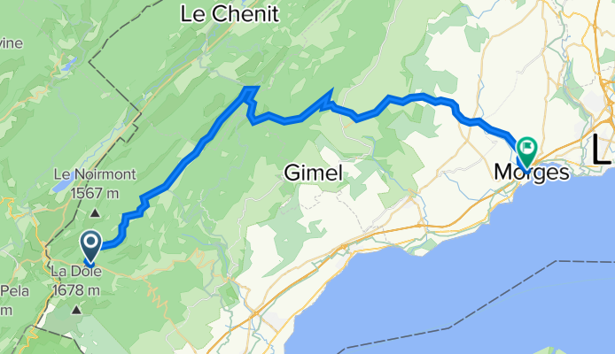
La Givrine - Marchairuz - Morges
A cycling route starting in Saint-Cergue, Canton of Vaud, Switzerland.
Overview
About this route
Rando VTT à travers la nature préservée du Jura, sur routes d'alpage, pistes forestières et chemins de randonnée pédestre. La neige peut persister tard au printemps dans la forêt et les sections à l'ombre, où la boue est également présente. Attention au trafic sur la route du Marchairuz le week-end et en semaine sur la route Bière-Ballens-Apples.
Distance : 46 km
Dénivelé positif : 400 m
Altitude maximale : 1449 m (col du Marchairuz)
Plus d'informations sur www.europebybike.info
- -:--
- Duration
- 45.8 km
- Distance
- 377 m
- Ascent
- 1,215 m
- Descent
- ---
- Avg. speed
- ---
- Avg. speed

Route quality
Waytypes & surfaces along the route
Waytypes
Track
18.2 km
(40 %)
Road
17.1 km
(37 %)
Surfaces
Paved
16.7 km
(36 %)
Unpaved
7.5 km
(16 %)
Asphalt
9.1 km
(20 %)
Paved (undefined)
7.6 km
(17 %)
Continue with Bikemap
Use, edit, or download this cycling route
You would like to ride La Givrine - Marchairuz - Morges or customize it for your own trip? Here is what you can do with this Bikemap route:
Free features
- Save this route as favorite or in collections
- Copy & plan your own version of this route
- Sync your route with Garmin or Wahoo
Premium features
Free trial for 3 days, or one-time payment. More about Bikemap Premium.
- Navigate this route on iOS & Android
- Export a GPX / KML file of this route
- Create your custom printout (try it for free)
- Download this route for offline navigation
Discover more Premium features.
Get Bikemap PremiumFrom our community
Other popular routes starting in Saint-Cergue
 St-Cergue-La Barillette?? à Ä„Ω??
- Distance
- 18.1 km
- Ascent
- 876 m
- Descent
- 883 m
- Location
- Saint-Cergue, Canton of Vaud, Switzerland
 Untitled route
- Distance
- 62.9 km
- Ascent
- 1,360 m
- Descent
- 1,871 m
- Location
- Saint-Cergue, Canton of Vaud, Switzerland
 St Cergue - Grutli - Les Fruitieres de Nyon
- Distance
- 24.8 km
- Ascent
- 653 m
- Descent
- 610 m
- Location
- Saint-Cergue, Canton of Vaud, Switzerland
 Bourg-en-Bresse - Les Rousses
- Distance
- 179 km
- Ascent
- 1,894 m
- Descent
- 2,728 m
- Location
- Saint-Cergue, Canton of Vaud, Switzerland
 Jura2011(B): Col de la Givrine bis Goumois
- Distance
- 191.2 km
- Ascent
- 1,351 m
- Descent
- 2,062 m
- Location
- Saint-Cergue, Canton of Vaud, Switzerland
 France Ultime : Belfort - Les Rousses
- Distance
- 214.3 km
- Ascent
- 1,500 m
- Descent
- 2,208 m
- Location
- Saint-Cergue, Canton of Vaud, Switzerland
 St Cergue - Grutli - Les Fruitieres de Nyon
- Distance
- 24.8 km
- Ascent
- 503 m
- Descent
- 506 m
- Location
- Saint-Cergue, Canton of Vaud, Switzerland
 sommet baudichone - givrine
- Distance
- 8.1 km
- Ascent
- 187 m
- Descent
- 378 m
- Location
- Saint-Cergue, Canton of Vaud, Switzerland
Open it in the app