
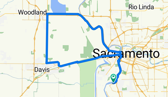
T50 50 Mile Route 2016
A cycling route starting in Parkway, California, United States.
Overview
About this route
- -:--
- Duration
- 78.2 km
- Distance
- 55 m
- Ascent
- 55 m
- Descent
- ---
- Avg. speed
- ---
- Max. altitude

Route quality
Waytypes & surfaces along the route
Waytypes
Cycleway
18 km
(23 %)
Road
8.6 km
(11 %)
Surfaces
Paved
31.3 km
(40 %)
Asphalt
23.5 km
(30 %)
Paved (undefined)
7 km
(9 %)
Route highlights
Points of interest along the route
Point of interest after 6.1 km
Rest stop 4
Accommodation after 8 km
Emergency Medical Services Sutter Medical Center 2825 Capitol Ave, Sacramento, CA 95816 suttermedicalcenter.org (916) 887-0000
Point of interest after 21.3 km
Rest stop 1 38.565240, -121.639413
Accommodation after 31.1 km
Emergency Medical Services Sutter Davis Hospital 2000 Sutter Pl, Davis, CA 95616 sutterdavis.org (530) 757-5111
Point of interest after 40.1 km
Rest stop 2 38.654201, -121.728482
Accommodation after 40.8 km
Emergency Medical Services Woodland Healthcare 1325 Cottonwood St, Woodland, CA 95695 woodlandhealthcare.org (530) 662-3961
Point of interest after 54 km
Rest stop 3
Continue with Bikemap
Use, edit, or download this cycling route
You would like to ride T50 50 Mile Route 2016 or customize it for your own trip? Here is what you can do with this Bikemap route:
Free features
- Save this route as favorite or in collections
- Copy & plan your own version of this route
- Sync your route with Garmin or Wahoo
Premium features
Free trial for 3 days, or one-time payment. More about Bikemap Premium.
- Navigate this route on iOS & Android
- Export a GPX / KML file of this route
- Create your custom printout (try it for free)
- Download this route for offline navigation
Discover more Premium features.
Get Bikemap PremiumFrom our community
Other popular routes starting in Parkway
 3413 19th Ave, Sacramento to 3413 19th Ave, Sacramento
- Distance
- 18.9 km
- Ascent
- 52 m
- Descent
- 48 m
- Location
- Parkway, California, United States
 4925 Roosevelt Ave, Sacramento to 4920 Roosevelt Ave, Sacramento
- Distance
- 39.9 km
- Ascent
- 10 m
- Descent
- 17 m
- Location
- Parkway, California, United States
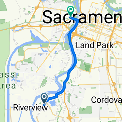 bike tour from Sacramento to West Sacramento
- Distance
- 11.1 km
- Ascent
- 39 m
- Descent
- 32 m
- Location
- Parkway, California, United States
 40 plus route
- Distance
- 69.3 km
- Ascent
- 27 m
- Descent
- 24 m
- Location
- Parkway, California, United States
 T50 50 Mile Ride
- Distance
- 82.8 km
- Ascent
- 82 m
- Descent
- 73 m
- Location
- Parkway, California, United States
 T50 50 Mile Ride Alternate
- Distance
- 84.4 km
- Ascent
- 39 m
- Descent
- 34 m
- Location
- Parkway, California, United States
 Old Sacramento
- Distance
- 15.5 km
- Ascent
- 21 m
- Descent
- 18 m
- Location
- Parkway, California, United States
 Lengthy Morning Track In Sacramento
- Distance
- 22 km
- Ascent
- 28 m
- Descent
- 33 m
- Location
- Parkway, California, United States
Open it in the app