

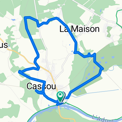
VIMPORT SAUBUSSE POR LA BARTHE
A cycling route starting in Rivière, Nouvelle-Aquitaine, France.
Overview
About this route
BARTHE ROUTE FROM SAUBUSSE ON THE DAX HENDAYA PATH ALONG THE SHORE OR RIGHT BANK OF THE ADOUR
IT IS A "PR" TYPE SECTION without cobblestones, except for the ones we carry in our heads, and with well-inflated tires it passes without problems, at least all the times I have passed there, a total of half a dozen times in both directions.
- -:--
- Duration
- 4.3 km
- Distance
- 8 m
- Ascent
- 9 m
- Descent
- ---
- Avg. speed
- ---
- Max. altitude

Route highlights
Points of interest along the route
Point of interest after 0.1 km
AQUI ESTA EL PASO CANADIENSE CON CADENA QUE SE PUEDE PASAR POR DEBAJO DE ELLA SIN PROBLEMAS
Point of interest after 1 km
AQUI ES DONDE ESTA EL MIXTO CADENA Y ALAMBRE DE ESPINO Y EL PASO ES UN POCO DIFICIL DE FRANQUEAR SI HAN VUELTO A PONER EL ALAMBRE, SE PUEDE PASAR LA BICI POR ENCIMA DE LA CADENA
Point of interest after 1.5 km
AQUI ES DONDE ESTA TOMADA LA FOTO DE LA RUTA
Continue with Bikemap
Use, edit, or download this cycling route
You would like to ride VIMPORT SAUBUSSE POR LA BARTHE or customize it for your own trip? Here is what you can do with this Bikemap route:
Free features
- Save this route as favorite or in collections
- Copy & plan your own version of this route
- Sync your route with Garmin or Wahoo
Premium features
Free trial for 3 days, or one-time payment. More about Bikemap Premium.
- Navigate this route on iOS & Android
- Export a GPX / KML file of this route
- Create your custom printout (try it for free)
- Download this route for offline navigation
Discover more Premium features.
Get Bikemap PremiumFrom our community
Other popular routes starting in Rivière
 Quai de l'Adour, Saubusse à Quai de l'Adour, Saubusse
- Distance
- 13.7 km
- Ascent
- 358 m
- Descent
- 362 m
- Location
- Rivière, Nouvelle-Aquitaine, France
 Coumet - Leone
- Distance
- 72.1 km
- Ascent
- 181 m
- Descent
- 196 m
- Location
- Rivière, Nouvelle-Aquitaine, France
 CIRCUIT SAUBUSSE_ADOUR
- Distance
- 40.2 km
- Ascent
- 203 m
- Descent
- 202 m
- Location
- Rivière, Nouvelle-Aquitaine, France
 Rivière-Saas-et-Gourby a 146–564 Quai de Bézincam, Saubusse
- Distance
- 6.3 km
- Ascent
- 6 m
- Descent
- 34 m
- Location
- Rivière, Nouvelle-Aquitaine, France
 saubusse Saubion
- Distance
- 16.1 km
- Ascent
- 30 m
- Descent
- 20 m
- Location
- Rivière, Nouvelle-Aquitaine, France
 1 Rue Lacave, Saubusse nach 1 Rue Lacave, Saubusse
- Distance
- 55.9 km
- Ascent
- 396 m
- Descent
- 396 m
- Location
- Rivière, Nouvelle-Aquitaine, France
 Rue Prat de la Grange, Saubusse à Route de Maremne, Saubusse
- Distance
- 19.2 km
- Ascent
- 177 m
- Descent
- 164 m
- Location
- Rivière, Nouvelle-Aquitaine, France
 Route stable en Pey
- Distance
- 24.6 km
- Ascent
- 463 m
- Descent
- 456 m
- Location
- Rivière, Nouvelle-Aquitaine, France
Open it in the app