

Tour de France 2016 dzień 20
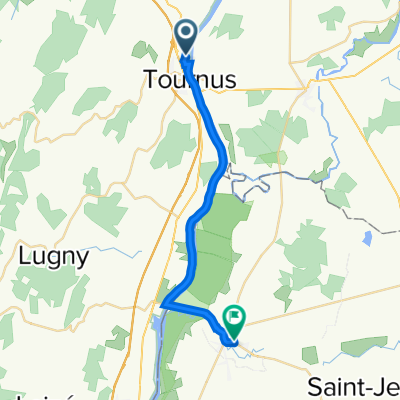
A cycling route starting in Tournus, Bourgogne-Franche-Comté, France.
Overview
About this route
20 DAY (0km, ca: 0m)
Saone – Le Taillet – Le Bas D’Ormes – Ormes – D933 – Tenarre – Boulay – Le Nassey – Le Meillenot – Velard (Rue de Chene-Chemin du Bourg A Velard-Rue du Mont-D38) – Grand Servigny (Route de Cortot) – Cortot – Montagny – Bey (N73) – Damerey – D970 – Ciel – Verdun sur le Doubs (D111) – Bragny sur Saone – Ecuelles – La Crose – Chivres (D115H) – La Rue du Bas (Etange Vernolot) – D996 – Corcelles les Citeaux – Noiron sours Gevrey (D109F) – Saulon la Chapelle (D31) – Layer – Breteniere (kanał) – DIJON (D107A) – Ahuy – D996 – Messigny et Vantoux – Saussy (Chemin de Tour) - Moloy – Crossroads D996 and D101K (forest)
- -:--
- Duration
- 141 km
- Distance
- 801 m
- Ascent
- 469 m
- Descent
- ---
- Avg. speed
- ---
- Max. altitude

Route quality
Waytypes & surfaces along the route
Waytypes
Road
36.7 km
(26 %)
Quiet road
26.8 km
(19 %)
Surfaces
Paved
43.7 km
(31 %)
Unpaved
1.4 km
(1 %)
Asphalt
42.3 km
(30 %)
Paved (undefined)
1.4 km
(1 %)
Continue with Bikemap
Use, edit, or download this cycling route
You would like to ride Tour de France 2016 dzień 20 or customize it for your own trip? Here is what you can do with this Bikemap route:
Free features
- Save this route as favorite or in collections
- Copy & plan your own version of this route
- Split it into stages to create a multi-day tour
- Sync your route with Garmin or Wahoo
Premium features
Free trial for 3 days, or one-time payment. More about Bikemap Premium.
- Navigate this route on iOS & Android
- Export a GPX / KML file of this route
- Create your custom printout (try it for free)
- Download this route for offline navigation
Discover more Premium features.
Get Bikemap PremiumFrom our community
Other popular routes starting in Tournus
 Tournus à 29 Impasse des Petites Granges, Pont-de-Vaux
- Distance
- 21 km
- Ascent
- 30 m
- Descent
- 33 m
- Location
- Tournus, Bourgogne-Franche-Comté, France
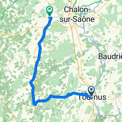
 • Maconnnais Tournus-Tournus mit Auto last vers
- Distance
- 41.2 km
- Ascent
- 319 m
- Descent
- 321 m
- Location
- Tournus, Bourgogne-Franche-Comté, France
 Tournus - Régnié-Durette
- Distance
- 65.3 km
- Ascent
- 197 m
- Descent
- 47 m
- Location
- Tournus, Bourgogne-Franche-Comté, France
 Tournus - Mâcon Hotel Park Inn
- Distance
- 32 km
- Ascent
- 29 m
- Descent
- 27 m
- Location
- Tournus, Bourgogne-Franche-Comté, France
 Tournus - Mâcon Hotel Park Inn
- Distance
- 30.7 km
- Ascent
- 26 m
- Descent
- 28 m
- Location
- Tournus, Bourgogne-Franche-Comté, France
 Truchère-Chagny
- Distance
- 61.8 km
- Ascent
- 201 m
- Descent
- 154 m
- Location
- Tournus, Bourgogne-Franche-Comté, France
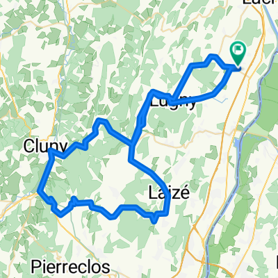 Uchizy clunisois A/R
- Distance
- 75.6 km
- Ascent
- 708 m
- Descent
- 706 m
- Location
- Tournus, Bourgogne-Franche-Comté, France
 Tournus-Cormatin-Givry
- Distance
- 50.1 km
- Ascent
- 497 m
- Descent
- 457 m
- Location
- Tournus, Bourgogne-Franche-Comté, France
Open it in the app