

jelenia góra - zebrzydów
A cycling route starting in Podgórzyn, Lower Silesian Voivodeship, Poland.
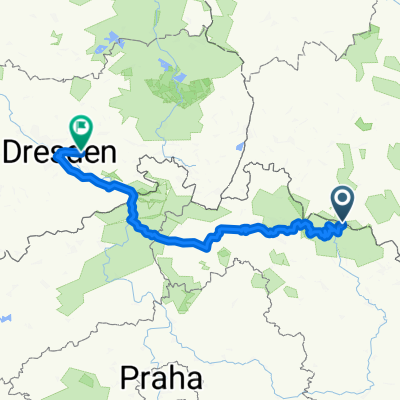
Overview
About this route
- -:--
- Duration
- 94.7 km
- Distance
- 665 m
- Ascent
- 824 m
- Descent
- ---
- Avg. speed
- ---
- Max. altitude

Route quality
Waytypes & surfaces along the route
Waytypes
Road
33.1 km
(35 %)
Track
18 km
(19 %)
Surfaces
Paved
49.2 km
(52 %)
Unpaved
5.7 km
(6 %)
Asphalt
48.3 km
(51 %)
Ground
3.8 km
(4 %)
Continue with Bikemap
Use, edit, or download this cycling route
You would like to ride jelenia góra - zebrzydów or customize it for your own trip? Here is what you can do with this Bikemap route:
Free features
- Save this route as favorite or in collections
- Copy & plan your own version of this route
- Split it into stages to create a multi-day tour
- Sync your route with Garmin or Wahoo
Premium features
Free trial for 3 days, or one-time payment. More about Bikemap Premium.
- Navigate this route on iOS & Android
- Export a GPX / KML file of this route
- Create your custom printout (try it for free)
- Download this route for offline navigation
Discover more Premium features.
Get Bikemap PremiumFrom our community
Other popular routes starting in Podgórzyn
 Krkonošská pivní stezka
- Distance
- 30.1 km
- Ascent
- 543 m
- Descent
- 1,266 m
- Location
- Podgórzyn, Lower Silesian Voivodeship, Poland
 Krkonošská pivní stezka - Špindlerovka - Slezský dům - Sněžka - Luční bouda - Friesovy boudy - Pivovar Hendrych - Vrchlabí
- Distance
- 32.4 km
- Ascent
- 625 m
- Descent
- 1,340 m
- Location
- Podgórzyn, Lower Silesian Voivodeship, Poland
 07.04.19 Lucni Bouda
- Distance
- 27.7 km
- Ascent
- 1,470 m
- Descent
- 1,351 m
- Location
- Podgórzyn, Lower Silesian Voivodeship, Poland
 AMP Przesieka dzień pierwszy
- Distance
- 12.9 km
- Ascent
- 350 m
- Descent
- 350 m
- Location
- Podgórzyn, Lower Silesian Voivodeship, Poland
 Riesengebirge Tag 3
- Distance
- 248.6 km
- Ascent
- 3,617 m
- Descent
- 4,662 m
- Location
- Podgórzyn, Lower Silesian Voivodeship, Poland
 09.09.2020 SINGLE Olbrzymy
- Distance
- 22.2 km
- Ascent
- 310 m
- Descent
- 309 m
- Location
- Podgórzyn, Lower Silesian Voivodeship, Poland
 Mushrooming trip in Karkonosze Mts
- Distance
- 19.4 km
- Ascent
- 507 m
- Descent
- 507 m
- Location
- Podgórzyn, Lower Silesian Voivodeship, Poland
 Przesieka-Přeseka 2018
- Distance
- 332.2 km
- Ascent
- 1,479 m
- Descent
- 1,577 m
- Location
- Podgórzyn, Lower Silesian Voivodeship, Poland
Open it in the app