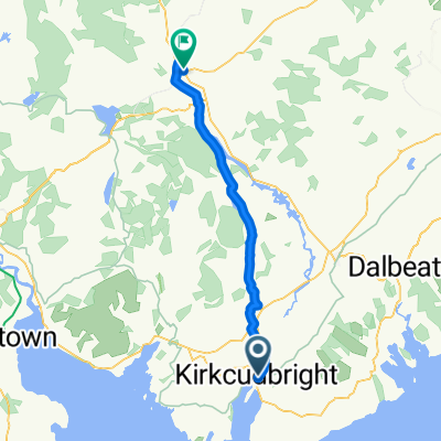
St Ninian's Way - Gatehouse of Fleet to Creetown
A cycling route starting in Kirkcudbright, Scotland, United Kingdom.
Overview
About this route
The 8th section of St Ninian’s Way follows Bike Route 7 west out of Gatehouse of Fleet for 300m to T junction by church. Here BR 7 goes north but the Way continues along road and track to Anwoth (1 km) and on to the Old Military Road , which meanders through the hills to Balloch Bridge and then down into Creetown on Wigtown Bay.
Starting with a steep rise and meandering through hills and moorland.
For a map overview of Part 1 and Part 2 of St Ninian’s Way please go to https://www.bikemap.net/en/route/3548129-st-ninians-way-carlisle-to-st-andrews-part-1-carlisle-to-whithorn/
St Ninian’s Way is one of the great pilgrim routes in Scotland to St Andrews - The Way of St Andrews - For other routes see http://www.thewayofstandrews.com
- -:--
- Duration
- 14.5 km
- Distance
- 339 m
- Ascent
- 343 m
- Descent
- ---
- Avg. speed
- ---
- Avg. speed
Route quality
Waytypes & surfaces along the route
Waytypes
Quiet road
8.8 km
(61 %)
Track
3 km
(21 %)
Surfaces
Paved
1 km
(7 %)
Unpaved
4 km
(28 %)
Gravel
3.8 km
(26 %)
Asphalt
1 km
(7 %)
Route highlights
Points of interest along the route
Point of interest after 1.1 km
Cardoness Castle
Point of interest after 12.5 km
Balloch Bridge
Continue with Bikemap
Use, edit, or download this cycling route
You would like to ride St Ninian's Way - Gatehouse of Fleet to Creetown or customize it for your own trip? Here is what you can do with this Bikemap route:
Free features
- Save this route as favorite or in collections
- Copy & plan your own version of this route
- Sync your route with Garmin or Wahoo
Premium features
Free trial for 3 days, or one-time payment. More about Bikemap Premium.
- Navigate this route on iOS & Android
- Export a GPX / KML file of this route
- Create your custom printout (try it for free)
- Download this route for offline navigation
Discover more Premium features.
Get Bikemap PremiumFrom our community
Other popular routes starting in Kirkcudbright
- Hames
- Distance
- 31.8 km
- Ascent
- 259 m
- Descent
- 259 m
- Location
- Kirkcudbright, Scotland, United Kingdom
- gatehouse of fleet 28 km
- Distance
- 28.4 km
- Ascent
- 347 m
- Descent
- 347 m
- Location
- Kirkcudbright, Scotland, United Kingdom
- Borgue to Kirkudbright
- Distance
- 19.1 km
- Ascent
- 161 m
- Descent
- 161 m
- Location
- Kirkcudbright, Scotland, United Kingdom
- Kirkcudbright loop
- Distance
- 25.9 km
- Ascent
- 9 m
- Descent
- 25 m
- Location
- Kirkcudbright, Scotland, United Kingdom
- 40A Saint Cuthbert Street, Kirkcudbright to A762, Castle Douglas
- Distance
- 16.5 km
- Ascent
- 176 m
- Descent
- 113 m
- Location
- Kirkcudbright, Scotland, United Kingdom
- Rutherford Hall, High St, Castle Douglas to 19 St Cuthbert St, Kirkcudbright
- Distance
- 25.4 km
- Ascent
- 267 m
- Descent
- 252 m
- Location
- Kirkcudbright, Scotland, United Kingdom
- Borge to Gatehouse of Fleet
- Distance
- 11.4 km
- Ascent
- 67 m
- Descent
- 115 m
- Location
- Kirkcudbright, Scotland, United Kingdom
- Gatehouse/Galloway Forest
- Distance
- 165 km
- Ascent
- 1,242 m
- Descent
- 1,242 m
- Location
- Kirkcudbright, Scotland, United Kingdom