

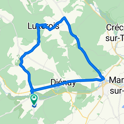
Tour de France 2016 dzień 21
A cycling route starting in Is-sur-Tille, Bourgogne-Franche-Comté, France.
Overview
About this route
Las – Chatellenot – Essarois (D29) – Chatillon sur Seine (D971) – Montliot et Courcelles – Villers Patras – Charrey sur Seine – Mussy sur Seine – D671 – Neuville sur Seine – Bar sur Seine – Virey sous Bar – Foucheres – Saint Parres les Vaudes – Boucheres (D444A-D444) – TROYES (D619) – D442 – Le Pavillon Sainte Julie – Echemines – Saint Flavy – Marigny le Chatel – La Fosse Corduan – Ferreux Quincey – Saint Aubin – Saint Aubin (las)
- -:--
- Duration
- 164.2 km
- Distance
- 242 m
- Ascent
- 660 m
- Descent
- ---
- Avg. speed
- ---
- Max. altitude

Route quality
Waytypes & surfaces along the route
Waytypes
Road
29.5 km
(18 %)
Quiet road
24.6 km
(15 %)
Surfaces
Paved
73.9 km
(45 %)
Unpaved
6.6 km
(4 %)
Asphalt
73.9 km
(45 %)
Ground
4.9 km
(3 %)
Route highlights
Points of interest along the route
Accommodation after 164.2 km
nocleg 21
Continue with Bikemap
Use, edit, or download this cycling route
You would like to ride Tour de France 2016 dzień 21 or customize it for your own trip? Here is what you can do with this Bikemap route:
Free features
- Save this route as favorite or in collections
- Copy & plan your own version of this route
- Split it into stages to create a multi-day tour
- Sync your route with Garmin or Wahoo
Premium features
Free trial for 3 days, or one-time payment. More about Bikemap Premium.
- Navigate this route on iOS & Android
- Export a GPX / KML file of this route
- Create your custom printout (try it for free)
- Download this route for offline navigation
Discover more Premium features.
Get Bikemap PremiumFrom our community
Other popular routes starting in Is-sur-Tille
 Tour de France 2016 dzień 21
- Distance
- 164.2 km
- Ascent
- 242 m
- Descent
- 660 m
- Location
- Is-sur-Tille, Bourgogne-Franche-Comté, France
 belle rando
- Distance
- 59.5 km
- Ascent
- 419 m
- Descent
- 422 m
- Location
- Is-sur-Tille, Bourgogne-Franche-Comté, France
 Noël 2017
- Distance
- 36.8 km
- Ascent
- 477 m
- Descent
- 476 m
- Location
- Is-sur-Tille, Bourgogne-Franche-Comté, France
 De 1 Rue du Moulin, Villecomte à 28 Grande Rue, Tarsul
- Distance
- 10.3 km
- Ascent
- 85 m
- Descent
- 47 m
- Location
- Is-sur-Tille, Bourgogne-Franche-Comté, France
 Sortie Villey
- Distance
- 60 km
- Ascent
- 486 m
- Descent
- 486 m
- Location
- Is-sur-Tille, Bourgogne-Franche-Comté, France
 Route de la Roche, Villecomte à Chemin de la Mortière, Villecomte
- Distance
- 25.4 km
- Ascent
- 344 m
- Descent
- 348 m
- Location
- Is-sur-Tille, Bourgogne-Franche-Comté, France
 Route de Vernot, Villecomte à Route de la Roche, Villecomte
- Distance
- 24.5 km
- Ascent
- 458 m
- Descent
- 428 m
- Location
- Is-sur-Tille, Bourgogne-Franche-Comté, France
 Boucle Moloy 1
- Distance
- 36.7 km
- Ascent
- 490 m
- Descent
- 490 m
- Location
- Is-sur-Tille, Bourgogne-Franche-Comté, France
Open it in the app