

2004, Tag 2, blau, Strasbourg-Mulhouse
A cycling route starting in Strasbourg, Grand Est, France.
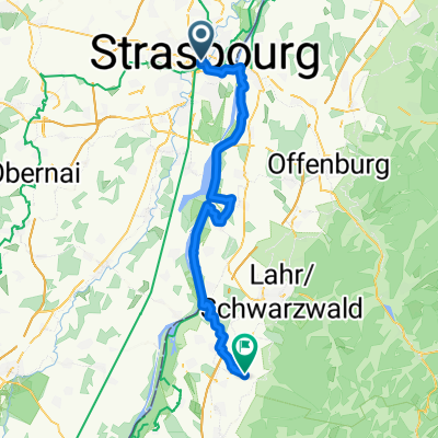
Overview
About this route
including transfer for the blue group to the lunch break alternative
- -:--
- Duration
- 127.3 km
- Distance
- 125 m
- Ascent
- 25 m
- Descent
- ---
- Avg. speed
- ---
- Max. altitude
Route highlights
Points of interest along the route
Point of interest after 28.7 km
1. Pause
Point of interest after 56.4 km
2. Pause
Point of interest after 74.9 km
Mittagspause in der Rheinmitte auf dem Parkplatz vor dem Campingplatz mit Blick auf die Altstadt
Point of interest after 101 km
4. Pause
Continue with Bikemap
Use, edit, or download this cycling route
You would like to ride 2004, Tag 2, blau, Strasbourg-Mulhouse or customize it for your own trip? Here is what you can do with this Bikemap route:
Free features
- Save this route as favorite or in collections
- Copy & plan your own version of this route
- Split it into stages to create a multi-day tour
- Sync your route with Garmin or Wahoo
Premium features
Free trial for 3 days, or one-time payment. More about Bikemap Premium.
- Navigate this route on iOS & Android
- Export a GPX / KML file of this route
- Create your custom printout (try it for free)
- Download this route for offline navigation
Discover more Premium features.
Get Bikemap PremiumFrom our community
Other popular routes starting in Strasbourg
 Day 3: Strasbourg to Offenburg
- Distance
- 24.2 km
- Ascent
- 61 m
- Descent
- 40 m
- Location
- Strasbourg, Grand Est, France
 "Grand" Parcours Route
- Distance
- 56.1 km
- Ascent
- 362 m
- Descent
- 357 m
- Location
- Strasbourg, Grand Est, France
 Strasbourg Drussenheim-Kehl-'Strasbourg
- Distance
- 66.4 km
- Ascent
- 64 m
- Descent
- 66 m
- Location
- Strasbourg, Grand Est, France
 Grand tour Bruche et Marne au Rhin
- Distance
- 107.8 km
- Ascent
- 387 m
- Descent
- 388 m
- Location
- Strasbourg, Grand Est, France
 Zomer 2017 - Strasbourg - Colmar (Eguisheim)
- Distance
- 82.5 km
- Ascent
- 94 m
- Descent
- 23 m
- Location
- Strasbourg, Grand Est, France
 28 juin 2018
- Distance
- 48.3 km
- Ascent
- 64 m
- Descent
- 61 m
- Location
- Strasbourg, Grand Est, France
 1. Strasbourg - Ettenheim
- Distance
- 57.4 km
- Ascent
- 189 m
- Descent
- 164 m
- Location
- Strasbourg, Grand Est, France
 Rue de l'Ail to Aristide Briand
- Distance
- 3.2 km
- Ascent
- 25 m
- Descent
- 35 m
- Location
- Strasbourg, Grand Est, France
Open it in the app