

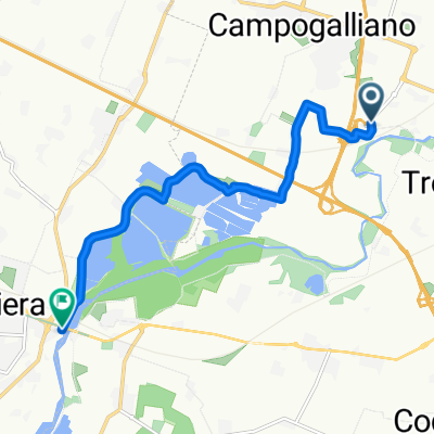
ViaE_Campogalliano_ Rubiera
A cycling route starting in Campogalliano, Emilia-Romagna, Italy.
Overview
About this route
dirt road
- 47 min
- Duration
- 8.3 km
- Distance
- 36 m
- Ascent
- 23 m
- Descent
- 10.5 km/h
- Avg. speed
- ---
- Max. altitude
Route quality
Waytypes & surfaces along the route
Waytypes
Quiet road
2.2 km
(27 %)
Access road
2.1 km
(25 %)
Surfaces
Paved
1.7 km
(20 %)
Unpaved
3.4 km
(41 %)
Gravel
1.7 km
(21 %)
Asphalt
1.7 km
(20 %)
Continue with Bikemap
Use, edit, or download this cycling route
You would like to ride ViaE_Campogalliano_ Rubiera or customize it for your own trip? Here is what you can do with this Bikemap route:
Free features
- Save this route as favorite or in collections
- Copy & plan your own version of this route
- Sync your route with Garmin or Wahoo
Premium features
Free trial for 3 days, or one-time payment. More about Bikemap Premium.
- Navigate this route on iOS & Android
- Export a GPX / KML file of this route
- Create your custom printout (try it for free)
- Download this route for offline navigation
Discover more Premium features.
Get Bikemap PremiumFrom our community
Other popular routes starting in Campogalliano
 ViaE_Campogalliano_ Rubiera
- Distance
- 8.3 km
- Ascent
- 36 m
- Descent
- 23 m
- Location
- Campogalliano, Emilia-Romagna, Italy
 Laghi Curiel - Modena centro
- Distance
- 8 km
- Ascent
- 45 m
- Descent
- 53 m
- Location
- Campogalliano, Emilia-Romagna, Italy
 Da Via Massimo d'Antona 27, Campogalliano a Via Massimo d'Antona 27, Campogalliano
- Distance
- 78.2 km
- Ascent
- 790 m
- Descent
- 790 m
- Location
- Campogalliano, Emilia-Romagna, Italy
 Famiglie in bici, Rubiera San Faustino Campogalliano
- Distance
- 18.9 km
- Ascent
- 41 m
- Descent
- 40 m
- Location
- Campogalliano, Emilia-Romagna, Italy
 MODENA - CORCAGNANO
- Distance
- 79.8 km
- Ascent
- 254 m
- Descent
- 169 m
- Location
- Campogalliano, Emilia-Romagna, Italy
 Italy8
- Distance
- 94.8 km
- Ascent
- 44 m
- Descent
- 36 m
- Location
- Campogalliano, Emilia-Romagna, Italy
 Supersonic route in Correggio
- Distance
- 15.3 km
- Ascent
- 4 m
- Descent
- 12 m
- Location
- Campogalliano, Emilia-Romagna, Italy
 Campogalliano - Passo Cipollaio - Pietrasanta
- Distance
- 145.1 km
- Ascent
- 2,296 m
- Descent
- 2,275 m
- Location
- Campogalliano, Emilia-Romagna, Italy
Open it in the app