

Adlersberg (Rückweg: Schmiedefeld-Stützerbach-Gehlberg-Großer Beerberg)
A cycling route starting in Schmiedefeld am Rennsteig, Thuringia, Germany.
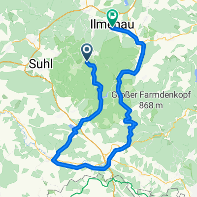
Overview
About this route
The round trip totals 105 km and even on this map adds up to more than 2,000 meters of elevation – I started the return journey at about 850 mNN, the destination is at 375 Hm, nevertheless about 1,000 Hm uphill – this doesn't happen by chance – I know most of the paths – not all – that is why I had to turn back a bit this time because the marked path did not exist in the bottom of the Zahme Gera – at Beerberg I had completed 31 km from Adlersberg – at CCS in Suhl it was 40 km – so 9 km downhill – but uphill the Suhler Leube is not passable – the path is too ruined and too steep – it is a hiking path – but there was a shortcut downhill – the rest was a bike path, since it was 19:10 at Beerberg and I was already through Wichtshausen by 20:00 – however, concrete paths only have 'charm' when it’s time to finish work.
- -:--
- Duration
- 54.5 km
- Distance
- 699 m
- Ascent
- 1,135 m
- Descent
- ---
- Avg. speed
- ---
- Max. altitude
Continue with Bikemap
Use, edit, or download this cycling route
You would like to ride Adlersberg (Rückweg: Schmiedefeld-Stützerbach-Gehlberg-Großer Beerberg) or customize it for your own trip? Here is what you can do with this Bikemap route:
Free features
- Save this route as favorite or in collections
- Copy & plan your own version of this route
- Sync your route with Garmin or Wahoo
Premium features
Free trial for 3 days, or one-time payment. More about Bikemap Premium.
- Navigate this route on iOS & Android
- Export a GPX / KML file of this route
- Create your custom printout (try it for free)
- Download this route for offline navigation
Discover more Premium features.
Get Bikemap PremiumFrom our community
Other popular routes starting in Schmiedefeld am Rennsteig
 Knüllfeld und zurück
- Distance
- 55.3 km
- Ascent
- 1,073 m
- Descent
- 1,070 m
- Location
- Schmiedefeld am Rennsteig, Thuringia, Germany
 Ilmtal-Radweg
- Distance
- 0.3 km
- Ascent
- 0 m
- Descent
- 12 m
- Location
- Schmiedefeld am Rennsteig, Thuringia, Germany
 2017-05-07: Uwe's MTB Tour
- Distance
- 57.2 km
- Ascent
- 575 m
- Descent
- 843 m
- Location
- Schmiedefeld am Rennsteig, Thuringia, Germany
 Crux-Wegscheide-Stutenhaus
- Distance
- 14 km
- Ascent
- 275 m
- Descent
- 277 m
- Location
- Schmiedefeld am Rennsteig, Thuringia, Germany
 Vesser - Stutenhaus - Adlersberg - Skilift Goldlauter - Geiersberg
- Distance
- 11.3 km
- Ascent
- 619 m
- Descent
- 545 m
- Location
- Schmiedefeld am Rennsteig, Thuringia, Germany
 2018-06-09: Bhf Rennsteig - Werra-Quelle
- Distance
- 96.3 km
- Ascent
- 802 m
- Descent
- 1,075 m
- Location
- Schmiedefeld am Rennsteig, Thuringia, Germany
 Samstag-Abend-Lieblingsrunde
- Distance
- 77.6 km
- Ascent
- 1,384 m
- Descent
- 1,391 m
- Location
- Schmiedefeld am Rennsteig, Thuringia, Germany
 Adlersberg (Rückweg: Schmiedefeld-Stützerbach-Gehlberg-Großer Beerberg)
- Distance
- 54.5 km
- Ascent
- 699 m
- Descent
- 1,135 m
- Location
- Schmiedefeld am Rennsteig, Thuringia, Germany
Open it in the app