
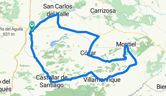
RUTA POR EL CAMPO DE MONTIEL
A cycling route starting in Valdepeñas, Castille-La Mancha, Spain.
Overview
About this route
Route covering 16 villages, including Valdepeñas, designed by Fernando Solera.
- -:--
- Duration
- 166.8 km
- Distance
- 668 m
- Ascent
- 678 m
- Descent
- ---
- Avg. speed
- ---
- Max. altitude

Route quality
Waytypes & surfaces along the route
Waytypes
Road
70 km
(42 %)
Quiet road
11.7 km
(7 %)
Surfaces
Unpaved
5 km
(3 %)
Gravel
5 km
(3 %)
Undefined
161.8 km
(97 %)
Continue with Bikemap
Use, edit, or download this cycling route
You would like to ride RUTA POR EL CAMPO DE MONTIEL or customize it for your own trip? Here is what you can do with this Bikemap route:
Free features
- Save this route as favorite or in collections
- Copy & plan your own version of this route
- Split it into stages to create a multi-day tour
- Sync your route with Garmin or Wahoo
Premium features
Free trial for 3 days, or one-time payment. More about Bikemap Premium.
- Navigate this route on iOS & Android
- Export a GPX / KML file of this route
- Create your custom printout (try it for free)
- Download this route for offline navigation
Discover more Premium features.
Get Bikemap PremiumFrom our community
Other popular routes starting in Valdepeñas
 VALDEPEÑAS-MORAL-BOLAÑOS-CRUCE DAIMIEL-VALDEPEÑAS
- Distance
- 74.1 km
- Ascent
- 231 m
- Descent
- 245 m
- Location
- Valdepeñas, Castille-La Mancha, Spain
 VALDEPEÑAS-SANTA ELENA POR CASTELLAR-ALDEAQUEMADA Y VUELTA
- Distance
- 155.8 km
- Ascent
- 1,383 m
- Descent
- 1,383 m
- Location
- Valdepeñas, Castille-La Mancha, Spain
 RUTA POR EL CAMPO DE MONTIEL
- Distance
- 166.8 km
- Ascent
- 668 m
- Descent
- 678 m
- Location
- Valdepeñas, Castille-La Mancha, Spain
 LOS CATORCE PUEBLOS DEL CAMPO DE MONTIEL
- Distance
- 158 km
- Ascent
- 674 m
- Descent
- 681 m
- Location
- Valdepeñas, Castille-La Mancha, Spain
 Valdepeñas-El Peral-San Carlos del Valle- Valdepeñas
- Distance
- 47.7 km
- Ascent
- 155 m
- Descent
- 155 m
- Location
- Valdepeñas, Castille-La Mancha, Spain
 VALDEPEÑAS-CRUCE SAN CARLOS-POZO-VALDEPEÑAS-PUENTE HIERRO-AGRUPADAS-VALDEPEÑAS
- Distance
- 66.9 km
- Ascent
- 175 m
- Descent
- 189 m
- Location
- Valdepeñas, Castille-La Mancha, Spain
 VALDEPEÑAS-MORAL-GRANATULA-ALDEA DEL REY-CALZADA-SANTA CRUZ-TORRENUEVA-VALDEPEÑAS
- Distance
- 107.3 km
- Ascent
- 275 m
- Descent
- 275 m
- Location
- Valdepeñas, Castille-La Mancha, Spain
 ALTERNATIVA A DESPEÑAPERROS
- Distance
- 92.7 km
- Ascent
- 1,125 m
- Descent
- 1,068 m
- Location
- Valdepeñas, Castille-La Mancha, Spain
Open it in the app