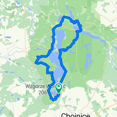
Ósemka Charzykowska
A cycling route starting in Chojnice, Pomeranian Voivodeship, Poland.
Overview
About this route
Figure eight route Charzykowy-small Sworne-Sworne-Charzykowy. Gentle, without tension.
- -:--
- Duration
- 49.6 km
- Distance
- 251 m
- Ascent
- 251 m
- Descent
- ---
- Avg. speed
- ---
- Max. altitude
Route quality
Waytypes & surfaces along the route
Waytypes
Cycleway
18.9 km
(38 %)
Track
11.4 km
(23 %)
Surfaces
Paved
19.3 km
(39 %)
Unpaved
8.4 km
(17 %)
Asphalt
14.4 km
(29 %)
Paved (undefined)
4.5 km
(9 %)
Route highlights
Points of interest along the route
Point of interest after 10.7 km
punkt odpoczynkowy
Point of interest after 22.3 km
jedzenie/piwo 😀
Point of interest after 22.7 km
pokoje/ supermarket
Point of interest after 32.2 km
jedzenie/ picie
Continue with Bikemap
Use, edit, or download this cycling route
You would like to ride Ósemka Charzykowska or customize it for your own trip? Here is what you can do with this Bikemap route:
Free features
- Save this route as favorite or in collections
- Copy & plan your own version of this route
- Sync your route with Garmin or Wahoo
Premium features
Free trial for 3 days, or one-time payment. More about Bikemap Premium.
- Navigate this route on iOS & Android
- Export a GPX / KML file of this route
- Create your custom printout (try it for free)
- Download this route for offline navigation
Discover more Premium features.
Get Bikemap PremiumFrom our community
Other popular routes starting in Chojnice
- Ósemka Charzykowska
- Distance
- 49.6 km
- Ascent
- 251 m
- Descent
- 251 m
- Location
- Chojnice, Pomeranian Voivodeship, Poland
- Charzykowy Tour
- Distance
- 38 km
- Ascent
- 180 m
- Descent
- 182 m
- Location
- Chojnice, Pomeranian Voivodeship, Poland
- Dookoła Charzykowskiego-Swornegacie-Charzykowy
- Distance
- 43.9 km
- Ascent
- 179 m
- Descent
- 181 m
- Location
- Chojnice, Pomeranian Voivodeship, Poland
- Struga 7 jezior 1
- Distance
- 38.5 km
- Ascent
- 135 m
- Descent
- 135 m
- Location
- Chojnice, Pomeranian Voivodeship, Poland
- Kaszuby - dzień 1
- Distance
- 47.5 km
- Ascent
- 355 m
- Descent
- 404 m
- Location
- Chojnice, Pomeranian Voivodeship, Poland
- Wyprawa nr 2
- Distance
- 49.9 km
- Ascent
- 163 m
- Descent
- 164 m
- Location
- Chojnice, Pomeranian Voivodeship, Poland
- po Parku Narodowym "Bory Tucholskie"
- Distance
- 31.9 km
- Ascent
- 155 m
- Descent
- 155 m
- Location
- Chojnice, Pomeranian Voivodeship, Poland
- chojnice- człuchów
- Distance
- 68.4 km
- Ascent
- 181 m
- Descent
- 179 m
- Location
- Chojnice, Pomeranian Voivodeship, Poland
Open it in the app