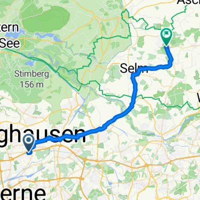
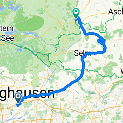
Erzbahntrasse (Ruhr)
A cycling route starting in Recklinghausen, North Rhine-Westphalia, Germany.
Overview
About this route
Die Anfang des 20. Jahrhunderts errichtete Bahnstrecke verband den Rhein-Herne-Kanal mit den Hochöfen des Bochumer Vereins und diente zur Versorgung mit Eisenerz. Heute ist die Trasse durchgängig als Radweg ausgebaut und verbindet den Resser Mark Westpark mit dem Zoo "Zoom" in Gelsenkirchen.
- -:--
- Duration
- 55.4 km
- Distance
- 209 m
- Ascent
- 190 m
- Descent
- ---
- Avg. speed
- ---
- Max. altitude
Route photos
Route quality
Waytypes & surfaces along the route
Waytypes
Path
30.1 km
(54 %)
Access road
7.2 km
(13 %)
Surfaces
Paved
40.4 km
(73 %)
Unpaved
8.4 km
(15 %)
Asphalt
33.2 km
(60 %)
Paving stones
6.6 km
(12 %)
Continue with Bikemap
Use, edit, or download this cycling route
You would like to ride Erzbahntrasse (Ruhr) or customize it for your own trip? Here is what you can do with this Bikemap route:
Free features
- Save this route as favorite or in collections
- Copy & plan your own version of this route
- Sync your route with Garmin or Wahoo
Premium features
Free trial for 3 days, or one-time payment. More about Bikemap Premium.
- Navigate this route on iOS & Android
- Export a GPX / KML file of this route
- Create your custom printout (try it for free)
- Download this route for offline navigation
Discover more Premium features.
Get Bikemap PremiumFrom our community
Other popular routes starting in Recklinghausen
- Von RE zum Rundkurs Unser-Fritz Ruhr nach Essen
- Distance
- 70.3 km
- Ascent
- 252 m
- Descent
- 249 m
- Location
- Recklinghausen, North Rhine-Westphalia, Germany
- Recklinghausen - Waltrop - Castrop
- Distance
- 33.5 km
- Ascent
- 165 m
- Descent
- 163 m
- Location
- Recklinghausen, North Rhine-Westphalia, Germany
- Recklinghausen Runde
- Distance
- 38.7 km
- Ascent
- 205 m
- Descent
- 202 m
- Location
- Recklinghausen, North Rhine-Westphalia, Germany
- Halterner Straße 16, Marl nach Halterner Straße 16, Marl
- Distance
- 30.2 km
- Ascent
- 328 m
- Descent
- 327 m
- Location
- Recklinghausen, North Rhine-Westphalia, Germany
- 13.05.2008 - 20:02
- Distance
- 23.8 km
- Ascent
- 61 m
- Descent
- 61 m
- Location
- Recklinghausen, North Rhine-Westphalia, Germany
- Marl Sinsen, Halterner Straße 16 - Flaesheim - Marl Sinsen
- Distance
- 26 km
- Ascent
- 253 m
- Descent
- 250 m
- Location
- Recklinghausen, North Rhine-Westphalia, Germany
- D - Recklinghausen - Rund um Recklinghausen (WAZ 10) - 43 km
- Distance
- 42.5 km
- Ascent
- 193 m
- Descent
- 193 m
- Location
- Recklinghausen, North Rhine-Westphalia, Germany
- Buchi's Runde
- Distance
- 58.8 km
- Ascent
- 321 m
- Descent
- 314 m
- Location
- Recklinghausen, North Rhine-Westphalia, Germany
Open it in the app