Rundtour Niederlausitzer Heidelandschaft
A cycling route starting in Hohenleipisch, Brandenburg, Germany.
Overview
About this route
Rundtour Niederlausitzer Heidelandschaft
- -:--
- Duration
- 39.1 km
- Distance
- 145 m
- Ascent
- 145 m
- Descent
- ---
- Avg. speed
- ---
- Avg. speed
Route quality
Waytypes & surfaces along the route
Waytypes
Track
18.6 km
(48 %)
Busy road
7.8 km
(20 %)
Surfaces
Paved
22.2 km
(57 %)
Unpaved
14.2 km
(36 %)
Asphalt
21.2 km
(54 %)
Gravel
12.1 km
(31 %)
Continue with Bikemap
Use, edit, or download this cycling route
You would like to ride Rundtour Niederlausitzer Heidelandschaft or customize it for your own trip? Here is what you can do with this Bikemap route:
Free features
- Save this route as favorite or in collections
- Copy & plan your own version of this route
- Sync your route with Garmin or Wahoo
Premium features
Free trial for 3 days, or one-time payment. More about Bikemap Premium.
- Navigate this route on iOS & Android
- Export a GPX / KML file of this route
- Create your custom printout (try it for free)
- Download this route for offline navigation
Discover more Premium features.
Get Bikemap PremiumFrom our community
Other popular routes starting in Hohenleipisch
- Gerade Fahrt in Hohenleipisch
- Distance
- 4 km
- Ascent
- 113 m
- Descent
- 114 m
- Location
- Hohenleipisch, Brandenburg, Germany
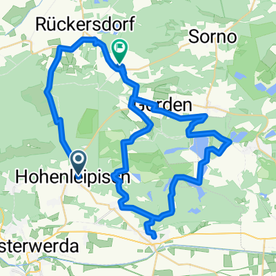
- Gorden, Gorden-Staupitz nach Seestraße 39, Potsdam
- Distance
- 127 km
- Ascent
- 469 m
- Descent
- 541 m
- Location
- Hohenleipisch, Brandenburg, Germany
- Unnamed Road, Hohenleipisch nach Thiemigstraße 9, Elsterwerda
- Distance
- 31.9 km
- Ascent
- 132 m
- Descent
- 149 m
- Location
- Hohenleipisch, Brandenburg, Germany
- Elsterradweg Hohenleipisch - Ruhland
- Distance
- 27.2 km
- Ascent
- 45 m
- Descent
- 86 m
- Location
- Hohenleipisch, Brandenburg, Germany
- Rundtour Niederlausitzer Heidelandschaft
- Distance
- 39.1 km
- Ascent
- 145 m
- Descent
- 145 m
- Location
- Hohenleipisch, Brandenburg, Germany
- Finsterwalde_Elsterwerda
- Distance
- 15.6 km
- Ascent
- 49 m
- Descent
- 60 m
- Location
- Hohenleipisch, Brandenburg, Germany
- Unnamed Road, Bad Liebenwerda nach Schulstraße 34, Bad Liebenwerda
- Distance
- 18.1 km
- Ascent
- 34 m
- Descent
- 39 m
- Location
- Hohenleipisch, Brandenburg, Germany
- Gerade Fahrt in Neuhausen/Spree
- Distance
- 84.6 km
- Ascent
- 284 m
- Descent
- 326 m
- Location
- Hohenleipisch, Brandenburg, Germany
Open it in the app