

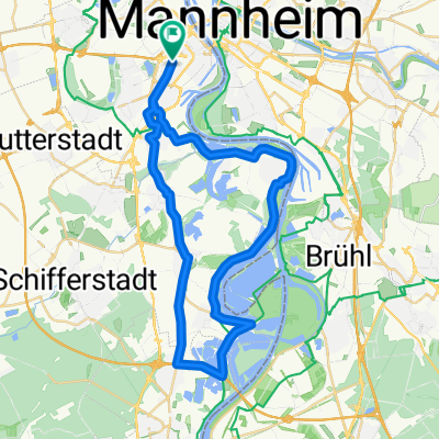
Mannheim - Speyer via Seckenheim, Schwetzingen und Otterstadt
A cycling route starting in Ludwigshafen am Rhein, Rhineland-Palatinate, Germany.
Overview
About this route
Dies ist eine Route für professionelle Radfahrer, was die Kondition anbetrifft. Auf den 42,64 Kilometer die man in dieser Tour absolviert fährt man an vielen Sehenswürdigkeiten vorbei und durch viele Städtchen. Nachdem wir aus der Mannheimer Innenstadt an den Neckar gelangen sind, radeln wir bis Seckenheim dort entlang und setzten dann durch den Rheinauer Dossenwald nach Rheinau Mitte um. Wir passieren den Rheinauer See und sind dann in der schönen Kreisstadt Schwetzingen. Die Kollerfähre erreichen wir über Brühl und seinen Rheinfriedhof und fahren dann via Otterstadt nach Speyer ein. Am Rhein entlang biegen wir in die Stadt ab und gelangen so zu unserem Zielpunkt, dem Hauptbahnhof.
- -:--
- Duration
- 42.7 km
- Distance
- 80 m
- Ascent
- 72 m
- Descent
- ---
- Avg. speed
- ---
- Max. altitude
Route quality
Waytypes & surfaces along the route
Waytypes
Track
9.6 km
(22 %)
Path
8.3 km
(20 %)
Surfaces
Paved
39.9 km
(93 %)
Unpaved
0 km
(<1 %)
Asphalt
36.5 km
(85 %)
Paving stones
3.1 km
(7 %)
Continue with Bikemap
Use, edit, or download this cycling route
You would like to ride Mannheim - Speyer via Seckenheim, Schwetzingen und Otterstadt or customize it for your own trip? Here is what you can do with this Bikemap route:
Free features
- Save this route as favorite or in collections
- Copy & plan your own version of this route
- Sync your route with Garmin or Wahoo
Premium features
Free trial for 3 days, or one-time payment. More about Bikemap Premium.
- Navigate this route on iOS & Android
- Export a GPX / KML file of this route
- Create your custom printout (try it for free)
- Download this route for offline navigation
Discover more Premium features.
Get Bikemap PremiumFrom our community
Other popular routes starting in Ludwigshafen am Rhein
 Von Mannheim bis Landau in der Pfalz
- Distance
- 67.9 km
- Ascent
- 223 m
- Descent
- 160 m
- Location
- Ludwigshafen am Rhein, Rhineland-Palatinate, Germany
 Rheinradweg Sandbachroute Schwarzwaldhochstraße
- Distance
- 157.2 km
- Ascent
- 829 m
- Descent
- 79 m
- Location
- Ludwigshafen am Rhein, Rhineland-Palatinate, Germany
 50 ziger Runde
- Distance
- 50.3 km
- Ascent
- 57 m
- Descent
- 57 m
- Location
- Ludwigshafen am Rhein, Rhineland-Palatinate, Germany
 ADFC Mannheim So,12.07.2009
- Distance
- 87.7 km
- Ascent
- 326 m
- Descent
- 323 m
- Location
- Ludwigshafen am Rhein, Rhineland-Palatinate, Germany
 43_Ludwigshafen – Friedelsheim – Bad Dürkheim
- Distance
- 24.7 km
- Ascent
- 62 m
- Descent
- 18 m
- Location
- Ludwigshafen am Rhein, Rhineland-Palatinate, Germany
 Von Mannheim bis Landau in der Pfalz
- Distance
- 53 km
- Ascent
- 179 m
- Descent
- 116 m
- Location
- Ludwigshafen am Rhein, Rhineland-Palatinate, Germany
 BASF Radtour 2011
- Distance
- 159.1 km
- Ascent
- 667 m
- Descent
- 668 m
- Location
- Ludwigshafen am Rhein, Rhineland-Palatinate, Germany
 Ludwigshafener Trainingsrunde
- Distance
- 41.2 km
- Ascent
- 63 m
- Descent
- 64 m
- Location
- Ludwigshafen am Rhein, Rhineland-Palatinate, Germany
Open it in the app