

Rhöntour - Burgsinn-Kreuzberg
A cycling route starting in Burgsinn, Bavaria, Germany.
Overview
About this route
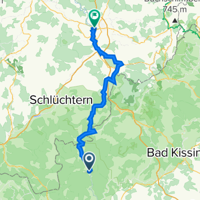
Day tour from Burgsinn train station to the summit of Kreuzberg (the highest mountain in the Bavarian Rhön). The monastery beer as a reward is mandatory. The wonderful track follows the partly wild stream-like Schondra towards its source.
- -:--
- Duration
- 47.5 km
- Distance
- 1,155 m
- Ascent
- 421 m
- Descent
- ---
- Avg. speed
- ---
- Max. altitude

Route quality
Waytypes & surfaces along the route
Waytypes
Track
35.1 km
(74 %)
Quiet road
7.6 km
(16 %)
Surfaces
Paved
11.9 km
(25 %)
Unpaved
32.8 km
(69 %)
Gravel
27.5 km
(58 %)
Asphalt
10 km
(21 %)
Continue with Bikemap
Use, edit, or download this cycling route
You would like to ride Rhöntour - Burgsinn-Kreuzberg or customize it for your own trip? Here is what you can do with this Bikemap route:
Free features
- Save this route as favorite or in collections
- Copy & plan your own version of this route
- Sync your route with Garmin or Wahoo
Premium features
Free trial for 3 days, or one-time payment. More about Bikemap Premium.
- Navigate this route on iOS & Android
- Export a GPX / KML file of this route
- Create your custom printout (try it for free)
- Download this route for offline navigation
Discover more Premium features.
Get Bikemap PremiumFrom our community
Other popular routes starting in Burgsinn
 Burgsinn500er
- Distance
- 39.2 km
- Ascent
- 599 m
- Descent
- 599 m
- Location
- Burgsinn, Bavaria, Germany
 Auf die Schanz
- Distance
- 46.9 km
- Ascent
- 408 m
- Descent
- 405 m
- Location
- Burgsinn, Bavaria, Germany
 Burgsinn_Grenzüberschreitende_Feierabendrunde
- Distance
- 33.2 km
- Ascent
- 440 m
- Descent
- 440 m
- Location
- Burgsinn, Bavaria, Germany
 Burgsinn - Adelsberg
- Distance
- 26.1 km
- Ascent
- 476 m
- Descent
- 381 m
- Location
- Burgsinn, Bavaria, Germany
 Kreuzbergtour
- Distance
- 133.9 km
- Ascent
- 1,253 m
- Descent
- 1,255 m
- Location
- Burgsinn, Bavaria, Germany
 Rhöntour drei
- Distance
- 171.6 km
- Ascent
- 1,285 m
- Descent
- 1,284 m
- Location
- Burgsinn, Bavaria, Germany
 Rhöntour - Burgsinn-Kreuzberg
- Distance
- 47.5 km
- Ascent
- 1,155 m
- Descent
- 421 m
- Location
- Burgsinn, Bavaria, Germany
 Burgsinn - Fulda
- Distance
- 72.8 km
- Ascent
- 788 m
- Descent
- 716 m
- Location
- Burgsinn, Bavaria, Germany
Open it in the app