

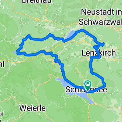
40_Aha – Bärental – Titisee
A cycling route starting in Schluchsee, Baden-Wurttemberg, Germany.
Overview
About this route
Dreiseen-Radweg im Hochschwarzwald Charakter: Ufernahe Wald- und Aussichtsrunde auf gut befahrbaren Forstwegen ohne nennenswerte Anstiege im Süden, am Nordufer hingegen bundesstraßennaher Radweg. Verkehr: Im Süden des Schluchsees durchgehend autofreie Forstwege, im Norden ebenfalls überwiegend autofrei, jedoch straßennah. Passender Reiseführer: KOMPASS 6412 Schwarzwald Süd, Bernhard Pollmann, ISBN 978-3-85026-763-2
- -:--
- Duration
- 16.3 km
- Distance
- 168 m
- Ascent
- 245 m
- Descent
- ---
- Avg. speed
- ---
- Max. altitude
Route quality
Waytypes & surfaces along the route
Waytypes
Track
5.5 km
(34 %)
Road
4.6 km
(28 %)
Surfaces
Paved
10.3 km
(63 %)
Unpaved
5.4 km
(33 %)
Asphalt
10.3 km
(63 %)
Loose gravel
3.1 km
(19 %)
Route highlights
Points of interest along the route
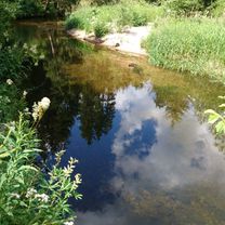
Point of interest after 2.8 km
Windgfällweiher. Bild-/ Textquelle: KOMPASS Verlag
Point of interest after 2.8 km
Windgfällweiher. Bild-/ Textquelle: KOMPASS Verlag
Point of interest after 2.8 km
Windgfällweiher. Bild-/ Textquelle: KOMPASS Verlag
Point of interest after 2.8 km
Windgfällweiher. Bild-/ Textquelle: KOMPASS Verlag
Point of interest after 2.8 km
Windgfällweiher. Bild-/ Textquelle: KOMPASS Verlag
Point of interest after 2.8 km
Windgfällweiher. Bild-/ Textquelle: KOMPASS Verlag
Continue with Bikemap
Use, edit, or download this cycling route
You would like to ride 40_Aha – Bärental – Titisee or customize it for your own trip? Here is what you can do with this Bikemap route:
Free features
- Save this route as favorite or in collections
- Copy & plan your own version of this route
- Sync your route with Garmin or Wahoo
Premium features
Free trial for 3 days, or one-time payment. More about Bikemap Premium.
- Navigate this route on iOS & Android
- Export a GPX / KML file of this route
- Create your custom printout (try it for free)
- Download this route for offline navigation
Discover more Premium features.
Get Bikemap PremiumFrom our community
Other popular routes starting in Schluchsee
 Schluchsee-Titisee-Windgfällweiher
- Distance
- 48.9 km
- Ascent
- 530 m
- Descent
- 530 m
- Location
- Schluchsee, Baden-Wurttemberg, Germany
 Schluchsee - St. Blasien - Menzenschwand - Feldberg
- Distance
- 45.7 km
- Ascent
- 908 m
- Descent
- 908 m
- Location
- Schluchsee, Baden-Wurttemberg, Germany
 schluchsee tour
- Distance
- 22.3 km
- Ascent
- 362 m
- Descent
- 362 m
- Location
- Schluchsee, Baden-Wurttemberg, Germany
 Hochschwarzwälder 4 Seen Tour
- Distance
- 50.4 km
- Ascent
- 1,106 m
- Descent
- 1,104 m
- Location
- Schluchsee, Baden-Wurttemberg, Germany
 Seenradweg Hochschwarzwald
- Distance
- 69.7 km
- Ascent
- 1,622 m
- Descent
- 1,624 m
- Location
- Schluchsee, Baden-Wurttemberg, Germany
 Wolfsgrund - Rothaus - Unterkrummen
- Distance
- 28.4 km
- Ascent
- 452 m
- Descent
- 444 m
- Location
- Schluchsee, Baden-Wurttemberg, Germany
 40_Aha – Bärental – Titisee
- Distance
- 16.3 km
- Ascent
- 168 m
- Descent
- 245 m
- Location
- Schluchsee, Baden-Wurttemberg, Germany
 Große Schluchsee-Tour
- Distance
- 27.1 km
- Ascent
- 592 m
- Descent
- 595 m
- Location
- Schluchsee, Baden-Wurttemberg, Germany
Open it in the app