

Tourentipp Larochette
A cycling route starting in Larochette, District de Luxembourg, Luxembourg.
Overview
About this route
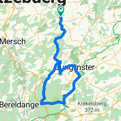
Description LAROCHETTE AND MEYSEMBURG The hiking tour leads from the beautiful village of Larochette along the Manzebach stream to Meysemburg. Here you can hike very comfortably – without big climbs. Difficulty: easy Distance: 8.1 km Ascent: 197 m Descent: 197 m Duration: 2:34 h Lowest point: 280 m Highest point: 366 m
- -:--
- Duration
- 8.1 km
- Distance
- 201 m
- Ascent
- 202 m
- Descent
- ---
- Avg. speed
- ---
- Max. altitude
Route quality
Waytypes & surfaces along the route
Waytypes
Track
5.5 km
(68 %)
Path
1.2 km
(15 %)
Surfaces
Paved
0.8 km
(10 %)
Unpaved
6.8 km
(84 %)
Ground
3.3 km
(41 %)
Unpaved (undefined)
2.3 km
(28 %)
Continue with Bikemap
Use, edit, or download this cycling route
You would like to ride Tourentipp Larochette or customize it for your own trip? Here is what you can do with this Bikemap route:
Free features
- Save this route as favorite or in collections
- Copy & plan your own version of this route
- Sync your route with Garmin or Wahoo
Premium features
Free trial for 3 days, or one-time payment. More about Bikemap Premium.
- Navigate this route on iOS & Android
- Export a GPX / KML file of this route
- Create your custom printout (try it for free)
- Download this route for offline navigation
Discover more Premium features.
Get Bikemap PremiumFrom our community
Other popular routes starting in Larochette
 Larochette-Bettel-Bollendorf-Christnach-Larochette
- Distance
- 55.7 km
- Ascent
- 481 m
- Descent
- 481 m
- Location
- Larochette, District de Luxembourg, Luxembourg
 Chemin J-A Zinnen 29, Larochette to Chemin J-A Zinnen 29, Larochette
- Distance
- 11.6 km
- Ascent
- 268 m
- Descent
- 268 m
- Location
- Larochette, District de Luxembourg, Luxembourg
 Larochette-Weiler-Vianden-Larochette
- Distance
- 70.3 km
- Ascent
- 665 m
- Descent
- 661 m
- Location
- Larochette, District de Luxembourg, Luxembourg
 Fels-Angelsberg-Nommern-Fels
- Distance
- 30.4 km
- Ascent
- 481 m
- Descent
- 481 m
- Location
- Larochette, District de Luxembourg, Luxembourg
 Dag 6: van Larochette naar Amel
- Distance
- 111.2 km
- Ascent
- 1,925 m
- Descent
- 1,801 m
- Location
- Larochette, District de Luxembourg, Luxembourg
 VTT Larochette
- Distance
- 26.5 km
- Ascent
- 412 m
- Descent
- 412 m
- Location
- Larochette, District de Luxembourg, Luxembourg
 Larochette-Senningerberg-Larochette
- Distance
- 46.4 km
- Ascent
- 318 m
- Descent
- 318 m
- Location
- Larochette, District de Luxembourg, Luxembourg
 Müllerthal light
- Distance
- 49.8 km
- Ascent
- 413 m
- Descent
- 413 m
- Location
- Larochette, District de Luxembourg, Luxembourg
Open it in the app