

Overview
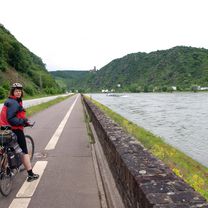
About this route
-
- 2016 s Věrou.
- -:--
- Duration
- 81.4 km
- Distance
- 187 m
- Ascent
- 207 m
- Descent
- ---
- Avg. speed
- ---
- Max. altitude

Part of
2016_05 Rýn
8 stages
Route quality
Waytypes & surfaces along the route
Waytypes
Path
37.4 km
(46 %)
Quiet road
18.7 km
(23 %)
Surfaces
Paved
49.7 km
(61 %)
Unpaved
4.1 km
(5 %)
Asphalt
46.4 km
(57 %)
Paved (undefined)
2.4 km
(3 %)
Continue with Bikemap
Use, edit, or download this cycling route
You would like to ride Spay_Mehlem or customize it for your own trip? Here is what you can do with this Bikemap route:
Free features
- Save this route as favorite or in collections
- Copy & plan your own version of this route
- Split it into stages to create a multi-day tour
- Sync your route with Garmin or Wahoo
Premium features
Free trial for 3 days, or one-time payment. More about Bikemap Premium.
- Navigate this route on iOS & Android
- Export a GPX / KML file of this route
- Create your custom printout (try it for free)
- Download this route for offline navigation
Discover more Premium features.
Get Bikemap PremiumFrom our community
Other popular routes starting in Osterspai
 Osterspai-Wellmich-Dahlheim-Prath-Lykershausen-Kamp Bornhofen-Osterspai
- Distance
- 39.1 km
- Ascent
- 483 m
- Descent
- 371 m
- Location
- Osterspai, Rhineland-Palatinate, Germany
 Schnatzenstraße nach Schnatzenstraße
- Distance
- 63.5 km
- Ascent
- 175 m
- Descent
- 229 m
- Location
- Osterspai, Rhineland-Palatinate, Germany
 Schnatzenstraße nach Schnatzenstraße
- Distance
- 62.9 km
- Ascent
- 622 m
- Descent
- 684 m
- Location
- Osterspai, Rhineland-Palatinate, Germany
 Kurze Osterspai, Kamp-Bornhofen, Filsen Tour
- Distance
- 10.6 km
- Ascent
- 227 m
- Descent
- 222 m
- Location
- Osterspai, Rhineland-Palatinate, Germany
 Rheinradweg Tag 13
- Distance
- 122.3 km
- Ascent
- 100 m
- Descent
- 120 m
- Location
- Osterspai, Rhineland-Palatinate, Germany
 Spay_Mehlem
- Distance
- 81.4 km
- Ascent
- 187 m
- Descent
- 207 m
- Location
- Osterspai, Rhineland-Palatinate, Germany
 Osterspai-Wellmich-Dahlheim-Dachsenhausen-Braubach-Osterspai
- Distance
- 49.4 km
- Ascent
- 727 m
- Descent
- 553 m
- Location
- Osterspai, Rhineland-Palatinate, Germany
 Osterspai, Lykershausen, Kamp-Bornhofen
- Distance
- 18.3 km
- Ascent
- 360 m
- Descent
- 359 m
- Location
- Osterspai, Rhineland-Palatinate, Germany
Open it in the app