

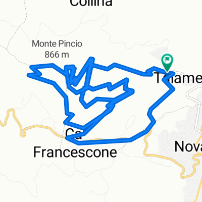
Talamello - Monte Pincio - Wolf 1 e Wolf 2
A cycling route starting in Talamello, Emilia-Romagna, Italy.
Overview
About this route
Due divertenti discese downhill sul Monte Pincio.
- -:--
- Duration
- 8.9 km
- Distance
- 570 m
- Ascent
- 571 m
- Descent
- ---
- Avg. speed
- ---
- Max. altitude
Route quality
Waytypes & surfaces along the route
Waytypes
Quiet road
5.4 km
(61 %)
Path
2.6 km
(30 %)
Surfaces
Paved
1.1 km
(12 %)
Unpaved
6.2 km
(70 %)
Gravel
2.8 km
(31 %)
Loose gravel
1.8 km
(20 %)
Continue with Bikemap
Use, edit, or download this cycling route
You would like to ride Talamello - Monte Pincio - Wolf 1 e Wolf 2 or customize it for your own trip? Here is what you can do with this Bikemap route:
Free features
- Save this route as favorite or in collections
- Copy & plan your own version of this route
- Sync your route with Garmin or Wahoo
Premium features
Free trial for 3 days, or one-time payment. More about Bikemap Premium.
- Navigate this route on iOS & Android
- Export a GPX / KML file of this route
- Create your custom printout (try it for free)
- Download this route for offline navigation
Discover more Premium features.
Get Bikemap PremiumFrom our community
Other popular routes starting in Talamello
 TALAMELLO
- Distance
- 6.5 km
- Ascent
- 602 m
- Descent
- 585 m
- Location
- Talamello, Emilia-Romagna, Italy
 Talamello . Monte Aquilone - Perticara - Monte Pincio - sentiero Wolf
- Distance
- 17 km
- Ascent
- 806 m
- Descent
- 805 m
- Location
- Talamello, Emilia-Romagna, Italy
 Da Via A. Galli 44A, Novafeltria a Sarsina
- Distance
- 17.9 km
- Ascent
- 553 m
- Descent
- 609 m
- Location
- Talamello, Emilia-Romagna, Italy
 Perticara_NF_Verukkio_ponteSA 50
- Distance
- 50 km
- Ascent
- 480 m
- Descent
- 989 m
- Location
- Talamello, Emilia-Romagna, Italy
 Talamello - Monte Pincio - Wolf 1 e Wolf 2
- Distance
- 8.9 km
- Ascent
- 570 m
- Descent
- 571 m
- Location
- Talamello, Emilia-Romagna, Italy
 Perticara - StAgata -Pennabilli - Cantoniera - Carpegna - Villagrande - San Leo -Ponte Verucchio - Santarcangelo
- Distance
- 100.6 km
- Ascent
- 1,260 m
- Descent
- 1,915 m
- Location
- Talamello, Emilia-Romagna, Italy
 Recovered Route
- Distance
- 44.4 km
- Ascent
- 14,467 m
- Descent
- 14,707 m
- Location
- Talamello, Emilia-Romagna, Italy
 Talamello Cycling
- Distance
- 18.1 km
- Ascent
- 964 m
- Descent
- 955 m
- Location
- Talamello, Emilia-Romagna, Italy
Open it in the app