

II Morciencuentros
BCB II Morciencuentros 2. Mercerreyes - Contreras
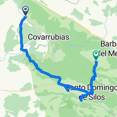
A cycling route starting in Mecerreyes, Castille and León, Spain.
Overview
About this route
We descend from Mecerreyes to Puentedura where one can bathe in the river. You need to leave the village towards Ura.
There, pass through the village until the town hall, then to the right until the last house in the village where we find a sign. To Castro, and there is the gorge of the river Mataviejas - very beautiful. One must go with great care and sense. It is ridable in parts - half or two-thirds; the others - pushing the bikes.
In Castroceniza we resume the road to Santibañez del Val where we are going to eat at the beautiful hermitage of Santa Cecilia.
From there we repeat the last stretch to the junction leading to Retuerta and Covarrubias - there is a steep and long climb, so one should eat well and save energy for the afternoon.
You must leave the road and go through Retuerta, there we take a path that leads to the gorge of Los Cerros. At the end to the right, passing by some barns and to Contreras. In Retuerta, one can take an alternative that consists of going from Retuerta to Contreras. It is harder, but less technical.
- -:--
- Duration
- 41.1 km
- Distance
- 420 m
- Ascent
- 375 m
- Descent
- ---
- Avg. speed
- ---
- Max. altitude

Part of
3 stages
Route quality
Waytypes & surfaces along the route
Waytypes
Road
16.4 km
(40 %)
Track
10.7 km
(26 %)
Surfaces
Paved
26.3 km
(64 %)
Unpaved
10.3 km
(25 %)
Asphalt
26.3 km
(64 %)
Gravel
7.8 km
(19 %)
Continue with Bikemap
Use, edit, or download this cycling route
You would like to ride BCB II Morciencuentros 2. Mercerreyes - Contreras or customize it for your own trip? Here is what you can do with this Bikemap route:
Free features
- Save this route as favorite or in collections
- Copy & plan your own version of this route
- Sync your route with Garmin or Wahoo
Premium features
Free trial for 3 days, or one-time payment. More about Bikemap Premium.
- Navigate this route on iOS & Android
- Export a GPX / KML file of this route
- Create your custom printout (try it for free)
- Download this route for offline navigation
Discover more Premium features.
Get Bikemap PremiumFrom our community
Other popular routes starting in Mecerreyes
 Et1 31jul dom:Mecerreyes-Covarrubias
- Distance
- 6.4 km
- Ascent
- 90 m
- Descent
- 177 m
- Location
- Mecerreyes, Castille and León, Spain
 Mecerreyes-Burgos
- Distance
- 42.9 km
- Ascent
- 229 m
- Descent
- 354 m
- Location
- Mecerreyes, Castille and León, Spain
 Covarrubias
- Distance
- 30.9 km
- Ascent
- 929 m
- Descent
- 930 m
- Location
- Mecerreyes, Castille and León, Spain
 Etapa 2 Morci/musi-cuentros
- Distance
- 41.7 km
- Ascent
- 521 m
- Descent
- 472 m
- Location
- Mecerreyes, Castille and León, Spain
 BCB II Morciencuentros 2. Mercerreyes - Contreras
- Distance
- 41.1 km
- Ascent
- 420 m
- Descent
- 375 m
- Location
- Mecerreyes, Castille and León, Spain
Open it in the app