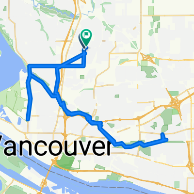
Lengthy ride through Burnt Bridge Creek trail
A cycling route starting in Hazel Dell, Washington, United States.
Overview
About this route
- 3 h 38 min
- Duration
- 42.2 km
- Distance
- 134 m
- Ascent
- 130 m
- Descent
- 11.6 km/h
- Avg. speed
- ---
- Max. altitude
Route quality
Waytypes & surfaces along the route
Waytypes
Path
25.6 km
(61 %)
Busy road
8.6 km
(20 %)
Surfaces
Paved
25.8 km
(61 %)
Unpaved
0.1 km
(<1 %)
Paved (undefined)
24.2 km
(57 %)
Asphalt
1.6 km
(4 %)
Route highlights
Points of interest along the route
Point of interest after 33.2 km
Under the freeway peace
Continue with Bikemap
Use, edit, or download this cycling route
You would like to ride Lengthy ride through Burnt Bridge Creek trail or customize it for your own trip? Here is what you can do with this Bikemap route:
Free features
- Save this route as favorite or in collections
- Copy & plan your own version of this route
- Sync your route with Garmin or Wahoo
Premium features
Free trial for 3 days, or one-time payment. More about Bikemap Premium.
- Navigate this route on iOS & Android
- Export a GPX / KML file of this route
- Create your custom printout (try it for free)
- Download this route for offline navigation
Discover more Premium features.
Get Bikemap PremiumFrom our community
Other popular routes starting in Hazel Dell
- Lengthy ride through Burnt Bridge Creek trail
- Distance
- 42.2 km
- Ascent
- 134 m
- Descent
- 130 m
- Location
- Hazel Dell, Washington, United States
- morning commute to work
- Distance
- 7.5 km
- Ascent
- 24 m
- Descent
- 44 m
- Location
- Hazel Dell, Washington, United States
- Northwest 56th Street 1511, Vancouver to Center Street Northeast 501, Salem
- Distance
- 102.2 km
- Ascent
- 1,209 m
- Descent
- 1,209 m
- Location
- Hazel Dell, Washington, United States
- 8223 NE 13th Pl, Vancouver to 1311 NE 82nd Way, Vancouver
- Distance
- 50.4 km
- Ascent
- 196 m
- Descent
- 257 m
- Location
- Hazel Dell, Washington, United States
- d
- Distance
- 0.6 km
- Ascent
- 17 m
- Descent
- 24 m
- Location
- Hazel Dell, Washington, United States
- Supersonic route in Vancouver
- Distance
- 13 km
- Ascent
- 57 m
- Descent
- 56 m
- Location
- Hazel Dell, Washington, United States
- 3701–3799 NE 81st St, Vancouver to 3706 NE 81st St, Vancouver
- Distance
- 58.5 km
- Ascent
- 26 m
- Descent
- 110 m
- Location
- Hazel Dell, Washington, United States
- Springwater
- Distance
- 30.7 km
- Ascent
- 278 m
- Descent
- 303 m
- Location
- Hazel Dell, Washington, United States
Open it in the app