

如來神掌
A cycling route starting in Taipei, Taipei, Taiwan.
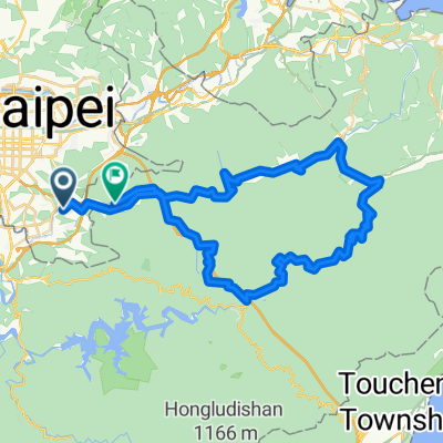
Overview
About this route
如來神掌
日期:2016年/ 06/04星期(下雨自動取消)(參加者請+1)
集合時間:06:30
出發時間:06:40
集合地點:興華國小旁停車場
騎乘時間:約8〜10小時左右(包含吃,喝,玩,樂時間)
時速:約10-45km,視路況而定
單車車種:不限,可正常行駛即可
距離:85KM(沿途7-11兵榔攤都能補給)
強度:★★★△(路線分級★= 1顆星=大部份是平路△=空三角型=有山路最多是5顆星)
路線:第一休息站(二子坪遊客中心 ),第二休息站(金山7-11),第三休閒站(石門7-11) ,第四休閒站(石門7-11),第五休閒站(劉家肉粽) ,第六休閒站(7-11)終點(興華國小旁停車場)
注意事項:
01.必備裝備:安全帽,適量的水,簡易補胎工具組、備胎及打氣筒、適量的金錢,健保卡及緊急連絡卡等。
02.夜騎必備裝備:前頭燈,後警示燈,並建議增加車輛之反光面積或著亮豔色衣物。
03.請務必確實遵守交通規則,以保障自身安全。在市區行進時,請以單台一列之方式前進,避免兩台或多台並排騎車。
04.行進中如需轉彎,請先檢視後方是否有來車,並伸出手作轉彎手勢,提醒後方車輛。
05.若路況不易辨識或前後方有來車,請大聲喊出前(後)有來車或路況情形,提醒其他車友。
06.本版活動活動,均為自發性活動,如已身發生不可預期之意外,不得以法律追究、壓隊等車友。
07.牽車是種美德,留著青山在,不怕沒柴燒。身體是自己的,千萬不要勉強。
08.運動強度自己決定,如果跟不上,就走自己的步調;因為運動,讓我更愛自己。
推動路線分級化制度:
★=往返50公里以內譬如市區臨港線
★★= 50〜100公里譬如茄萣情人碼頭岡山旗山美濃屏東
★★★= 100〜200公里譬如台南市區六龜楓港新化虎頭埤烏山頭水庫
★★★★= 200〜300公里譬如墾丁一日往返嘉義一日往返
★★★★★= 300公里以上譬如一日台北四個半小時內完成鐵屁股之役...
高度為準(當天騎乘為準)
海拔爬升總量500內............△不厭亭
海拔爬升總量1000內...........△△北大武
海拔爬升總量2000內.........△△△△塔塔加
海拔爬升總量4000內.............△△△△...
- -:--
- Duration
- 102.9 km
- Distance
- 2,045 m
- Ascent
- 2,036 m
- Descent
- ---
- Avg. speed
- ---
- Max. altitude

Route quality
Waytypes & surfaces along the route
Waytypes
Road
49.9 km
(48 %)
Busy road
33.3 km
(32 %)
Surfaces
Paved
27.4 km
(27 %)
Asphalt
27.1 km
(26 %)
Wood
0.2 km
(<1 %)
Route highlights
Points of interest along the route
Point of interest after 0.4 km
興華國小
Drinking water after 10.3 km
二子坪遊客中心
Drinking water after 30.9 km
金山7-11
Point of interest after 32.4 km
坡度: 5.66 %
Point of interest after 37.6 km
海拔: 300.81 M
Point of interest after 45.3 km
坡度: 3.05 %

Drinking water after 48.1 km
7-11
Point of interest after 54.5 km
海拔: 284.07 M
Drinking water after 62.2 km
劉家肉粽
Point of interest after 62.8 km
坡度: 5.21 %
Point of interest after 71.3 km
海拔: 470.48 M
Point of interest after 77.9 km
萊爾富
Point of interest after 80.7 km
坡度: 4.14 %
Point of interest after 88.3 km
海拔: 320.41 M
Point of interest after 95.2 km
坡度: 4.58 %
Drinking water after 95.2 km
7-11
Continue with Bikemap
Use, edit, or download this cycling route
You would like to ride 如來神掌 or customize it for your own trip? Here is what you can do with this Bikemap route:
Free features
- Save this route as favorite or in collections
- Copy & plan your own version of this route
- Split it into stages to create a multi-day tour
- Sync your route with Garmin or Wahoo
Premium features
Free trial for 3 days, or one-time payment. More about Bikemap Premium.
- Navigate this route on iOS & Android
- Export a GPX / KML file of this route
- Create your custom printout (try it for free)
- Download this route for offline navigation
Discover more Premium features.
Get Bikemap PremiumFrom our community
Other popular routes starting in Taipei
 秘境之旅-南港,汐止,平溪,石碇
- Distance
- 66.8 km
- Ascent
- 1,419 m
- Descent
- 1,418 m
- Location
- Taipei, Taipei, Taiwan
 Taiwan tour
- Distance
- 985.3 km
- Ascent
- 1,195 m
- Descent
- 1,194 m
- Location
- Taipei, Taipei, Taiwan
 Short bike tour through Taipei City
- Distance
- 3.2 km
- Ascent
- 295 m
- Descent
- 295 m
- Location
- Taipei, Taipei, Taiwan
 台北←→桃園三坑老街
- Distance
- 111 km
- Ascent
- 321 m
- Descent
- 315 m
- Location
- Taipei, Taipei, Taiwan
 小鐵人宜蘭兩日20160423
- Distance
- 89.5 km
- Ascent
- 585 m
- Descent
- 589 m
- Location
- Taipei, Taipei, Taiwan
 ironkidz_201510_微風車訓_FINAL
- Distance
- 40.1 km
- Ascent
- 73 m
- Descent
- 73 m
- Location
- Taipei, Taipei, Taiwan
 系列七 海王星-闊瀨尋奇
- Distance
- 82.8 km
- Ascent
- 1,299 m
- Descent
- 1,281 m
- Location
- Taipei, Taipei, Taiwan
 陽金3P
陽金3P- Distance
- 114.6 km
- Ascent
- 2,046 m
- Descent
- 1,741 m
- Location
- Taipei, Taipei, Taiwan
Open it in the app