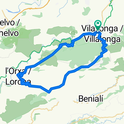
Villalonga - L'Orxa por Safor - Villalonga por La Llacuna
A cycling route starting in Villalonga, Valencia, Spain.
Overview
About this route
Villalonga - Reprimala - Safor - L'Orxa - La Llacuna - Villalonga
- -:--
- Duration
- 32.5 km
- Distance
- 948 m
- Ascent
- 948 m
- Descent
- ---
- Avg. speed
- ---
- Max. altitude
Continue with Bikemap
Use, edit, or download this cycling route
You would like to ride Villalonga - L'Orxa por Safor - Villalonga por La Llacuna or customize it for your own trip? Here is what you can do with this Bikemap route:
Free features
- Save this route as favorite or in collections
- Copy & plan your own version of this route
- Sync your route with Garmin or Wahoo
Premium features
Free trial for 3 days, or one-time payment. More about Bikemap Premium.
- Navigate this route on iOS & Android
- Export a GPX / KML file of this route
- Create your custom printout (try it for free)
- Download this route for offline navigation
Discover more Premium features.
Get Bikemap PremiumFrom our community
Other popular routes starting in Villalonga
València/Alacant: Villalonga-L'Orxa-Villalonga- Distance
- 28 km
- Ascent
- 585 m
- Descent
- 582 m
- Location
- Villalonga, Valencia, Spain
VI MARXA BTT EL LLOP 2014 (OFICIAL)- Distance
- 30.9 km
- Ascent
- 586 m
- Descent
- 587 m
- Location
- Villalonga, Valencia, Spain
Villalonga Reprimala-Lorxa- Distance
- 28.3 km
- Ascent
- 474 m
- Descent
- 474 m
- Location
- Villalonga, Valencia, Spain
Verbindings route ALC - SAC- Distance
- 48.7 km
- Ascent
- 68 m
- Descent
- 150 m
- Location
- Villalonga, Valencia, Spain
Villalonga - L'Orxa por Safor - Villalonga por La Llacuna- Distance
- 32.5 km
- Ascent
- 948 m
- Descent
- 948 m
- Location
- Villalonga, Valencia, Spain
Via verda del riu Serpis. Tramo 1: Villalonga - L'Orxa- Distance
- 32.3 km
- Ascent
- 441 m
- Descent
- 441 m
- Location
- Villalonga, Valencia, Spain
de la 3ª Marcha BTT El llop - Villalonga- Distance
- 38.1 km
- Ascent
- 967 m
- Descent
- 972 m
- Location
- Villalonga, Valencia, Spain
Villalonga - Denia- Distance
- 58.8 km
- Ascent
- 1,001 m
- Descent
- 1,104 m
- Location
- Villalonga, Valencia, Spain
Open it in the app

