

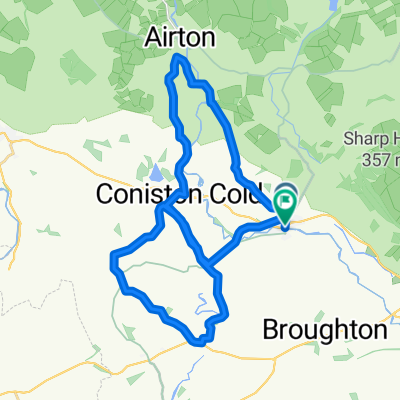
Airedale and Kilnsey Crag
A cycling route starting in Gargrave, England, United Kingdom.
Overview
About this route
Start Dalesman Cafe
- -:--
- Duration
- 59 km
- Distance
- 595 m
- Ascent
- 596 m
- Descent
- ---
- Avg. speed
- ---
- Max. altitude
Route quality
Waytypes & surfaces along the route
Waytypes
Quiet road
28.3 km
(48 %)
Road
23 km
(39 %)
Undefined
7.7 km
(13 %)
Surfaces
Paved
28.3 km
(48 %)
Asphalt
28.3 km
(48 %)
Undefined
30.7 km
(52 %)
Route highlights
Points of interest along the route
Point of interest after 13.8 km
KOM
Continue with Bikemap
Use, edit, or download this cycling route
You would like to ride Airedale and Kilnsey Crag or customize it for your own trip? Here is what you can do with this Bikemap route:
Free features
- Save this route as favorite or in collections
- Copy & plan your own version of this route
- Sync your route with Garmin or Wahoo
Premium features
Free trial for 3 days, or one-time payment. More about Bikemap Premium.
- Navigate this route on iOS & Android
- Export a GPX / KML file of this route
- Create your custom printout (try it for free)
- Download this route for offline navigation
Discover more Premium features.
Get Bikemap PremiumFrom our community
Other popular routes starting in Gargrave
 Gargrave & Slaidburn
- Distance
- 66.6 km
- Ascent
- 499 m
- Descent
- 515 m
- Location
- Gargrave, England, United Kingdom
 Gargrave lumpy loop
- Distance
- 27 km
- Ascent
- 291 m
- Descent
- 292 m
- Location
- Gargrave, England, United Kingdom
 Way of the Roses(3)
- Distance
- 66.4 km
- Ascent
- 486 m
- Descent
- 641 m
- Location
- Gargrave, England, United Kingdom
 wor day 1
- Distance
- 61.7 km
- Ascent
- 677 m
- Descent
- 598 m
- Location
- Gargrave, England, United Kingdom
 Gargrave to Keighley
- Distance
- 25.1 km
- Ascent
- 99 m
- Descent
- 106 m
- Location
- Gargrave, England, United Kingdom
 Route England/Scotland day 4
- Distance
- 103.9 km
- Ascent
- 883 m
- Descent
- 1,028 m
- Location
- Gargrave, England, United Kingdom
 Elaines Tea room
- Distance
- 73.8 km
- Ascent
- 977 m
- Descent
- 975 m
- Location
- Gargrave, England, United Kingdom
 "Gargrave & Slaidburn" w/o Slaidburn
- Distance
- 58.3 km
- Ascent
- 501 m
- Descent
- 501 m
- Location
- Gargrave, England, United Kingdom
Open it in the app