

Brzegami Popradu (Muszyna, Plaveč, Łomnica, Muszyna)
A cycling route starting in Muszyna, Lesser Poland Voivodeship, Poland.
Overview
About this route
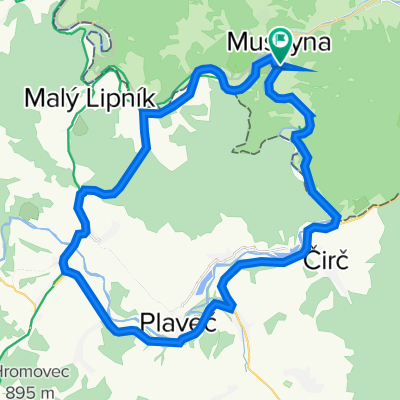
Trip to Plaveč and a passage along the shores of the Poprad River on the Slovak side. Access to the border at Leluchów from Muszyna, and nearby an experimental jump over a partisan bridge in Čirč' to the other side of the Poprad, after previously using a railway viaduct and a 400-meter gravel road, then access via a side asphalt road under Plaveč.
Here we return over another bridge on the Poprad to the main road and reach Plavnica, where after the third block we turn right to the pass via a footbridge shortcut, and after reaching the saddle, descend to Mały Lipnik. We continue the route with a passage along the shores of the Poprad up to Zavodie, where the asphalt road turns into a two-kilometer beaten track, to regain asphalt surface in Medzibrodie. In Mniszek we shorten again via steps at the pedestrian crossing and after crossing the new viaduct return to Poland. The end of the loop is a ride along the shores on the native side, with a short climb over a hill at Łopata Polska.
- -:--
- Duration
- 72.8 km
- Distance
- 493 m
- Ascent
- 493 m
- Descent
- ---
- Avg. speed
- ---
- Max. altitude

Route quality
Waytypes & surfaces along the route
Waytypes
Road
36.4 km
(50 %)
Quiet road
3.6 km
(5 %)
Surfaces
Paved
69.2 km
(95 %)
Unpaved
0.7 km
(1 %)
Asphalt
69.2 km
(95 %)
Gravel
0.7 km
(1 %)
Undefined
2.9 km
(4 %)
Continue with Bikemap
Use, edit, or download this cycling route
You would like to ride Brzegami Popradu (Muszyna, Plaveč, Łomnica, Muszyna) or customize it for your own trip? Here is what you can do with this Bikemap route:
Free features
- Save this route as favorite or in collections
- Copy & plan your own version of this route
- Sync your route with Garmin or Wahoo
Premium features
Free trial for 3 days, or one-time payment. More about Bikemap Premium.
- Navigate this route on iOS & Android
- Export a GPX / KML file of this route
- Create your custom printout (try it for free)
- Download this route for offline navigation
Discover more Premium features.
Get Bikemap PremiumFrom our community
Other popular routes starting in Muszyna
 Zegiestow_2015EtapIII
- Distance
- 28.2 km
- Ascent
- 486 m
- Descent
- 491 m
- Location
- Muszyna, Lesser Poland Voivodeship, Poland
 Muszyna-Leluchów-Plavec-Plavnica-Udol-Mały Lipnik-Legnava-Borysów-Muszyna
- Distance
- 38 km
- Ascent
- 543 m
- Descent
- 543 m
- Location
- Muszyna, Lesser Poland Voivodeship, Poland
 Wokół Pasma Jaworzyny Krynickiej
- Distance
- 109.6 km
- Ascent
- 930 m
- Descent
- 927 m
- Location
- Muszyna, Lesser Poland Voivodeship, Poland
 222222216.07-Muszyna-Leluchów-Muszyna
- Distance
- 36 km
- Ascent
- 600 m
- Descent
- 594 m
- Location
- Muszyna, Lesser Poland Voivodeship, Poland
 Muszyna1
- Distance
- 18.1 km
- Ascent
- 223 m
- Descent
- 225 m
- Location
- Muszyna, Lesser Poland Voivodeship, Poland
 duża pętla
- Distance
- 118.1 km
- Ascent
- 1,060 m
- Descent
- 1,060 m
- Location
- Muszyna, Lesser Poland Voivodeship, Poland
 Brzegami Popradu (Muszyna, Plaveč, Łomnica, Muszyna)
- Distance
- 72.8 km
- Ascent
- 493 m
- Descent
- 493 m
- Location
- Muszyna, Lesser Poland Voivodeship, Poland
 Mała pętla Muszyńska
- Distance
- 11.8 km
- Ascent
- 189 m
- Descent
- 189 m
- Location
- Muszyna, Lesser Poland Voivodeship, Poland
Open it in the app