

1. HND - Lake Yamanakako
A cycling route starting in Kawasaki, Kanagawa, Japan.
Overview
About this route
- -:--
- Duration
- 112.9 km
- Distance
- 1,310 m
- Ascent
- 328 m
- Descent
- ---
- Avg. speed
- ---
- Max. altitude

Route highlights
Points of interest along the route
Accommodation after 57.3 km
APA Hotel Sagamihara Hashimoto Ekimae
Accommodation after 85 km
CAmping
Accommodation after 89.9 km
CAMPING
Point of interest after 92.1 km
ONSEN
Accommodation after 92.9 km
CAMPING
Point of interest after 96.9 km
ONSEN
Continue with Bikemap
Use, edit, or download this cycling route
You would like to ride 1. HND - Lake Yamanakako or customize it for your own trip? Here is what you can do with this Bikemap route:
Free features
- Save this route as favorite or in collections
- Copy & plan your own version of this route
- Split it into stages to create a multi-day tour
- Sync your route with Garmin or Wahoo
Premium features
Free trial for 3 days, or one-time payment. More about Bikemap Premium.
- Navigate this route on iOS & Android
- Export a GPX / KML file of this route
- Create your custom printout (try it for free)
- Download this route for offline navigation
Discover more Premium features.
Get Bikemap PremiumFrom our community
Other popular routes starting in Kawasaki
 Enoshima
- Distance
- 41.9 km
- Ascent
- 296 m
- Descent
- 311 m
- Location
- Kawasaki, Kanagawa, Japan
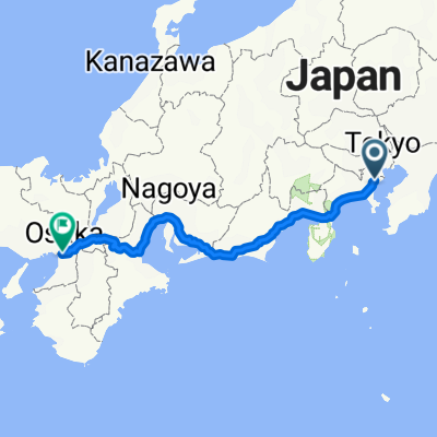 Japan: Osaka To Tokyo
- Distance
- 552.7 km
- Ascent
- 1,434 m
- Descent
- 1,453 m
- Location
- Kawasaki, Kanagawa, Japan
 5丁目 2, 川崎市 まで3丁目 20, 世田谷区
- Distance
- 17.9 km
- Ascent
- 109 m
- Descent
- 99 m
- Location
- Kawasaki, Kanagawa, Japan
 1 er partie 11 jours 53km/ j
- Distance
- 595.6 km
- Ascent
- 2,720 m
- Descent
- 2,656 m
- Location
- Kawasaki, Kanagawa, Japan
 Japan 2015
- Distance
- 4,047.9 km
- Ascent
- 2,662 m
- Descent
- 2,633 m
- Location
- Kawasaki, Kanagawa, Japan
 Japan trip
- Distance
- 1,088.1 km
- Ascent
- 3,026 m
- Descent
- 3,024 m
- Location
- Kawasaki, Kanagawa, Japan
 1-chōme, Kawasaki to 2-chōme 17, Fujisawa
- Distance
- 43.5 km
- Ascent
- 228 m
- Descent
- 232 m
- Location
- Kawasaki, Kanagawa, Japan
 Ruta constante en Shinagawa-Ku
- Distance
- 36.1 km
- Ascent
- 4 m
- Descent
- 26 m
- Location
- Kawasaki, Kanagawa, Japan
Open it in the app