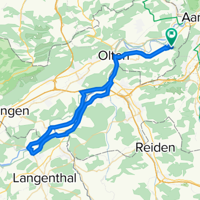
Schönenwerd Leibstadt Rundfahrt
A cycling route starting in Schönenwerd, Canton of Solothurn, Switzerland.
Overview
About this route
- -:--
- Duration
- 84.7 km
- Distance
- 488 m
- Ascent
- 488 m
- Descent
- ---
- Avg. speed
- ---
- Avg. speed
Route quality
Waytypes & surfaces along the route
Waytypes
Track
25.9 km
(31 %)
Quiet road
25.6 km
(30 %)
Surfaces
Paved
58.1 km
(69 %)
Unpaved
17.4 km
(21 %)
Asphalt
55 km
(65 %)
Gravel
16.4 km
(19 %)
Continue with Bikemap
Use, edit, or download this cycling route
You would like to ride Schönenwerd Leibstadt Rundfahrt or customize it for your own trip? Here is what you can do with this Bikemap route:
Free features
- Save this route as favorite or in collections
- Copy & plan your own version of this route
- Sync your route with Garmin or Wahoo
Premium features
Free trial for 3 days, or one-time payment. More about Bikemap Premium.
- Navigate this route on iOS & Android
- Export a GPX / KML file of this route
- Create your custom printout (try it for free)
- Download this route for offline navigation
Discover more Premium features.
Get Bikemap PremiumFrom our community
Other popular routes starting in Schönenwerd
- Bielackerstrasse 27, Gretzenbach nach Pfarrmattstrasse 18, Gretzenbach
- Distance
- 56.8 km
- Ascent
- 570 m
- Descent
- 573 m
- Location
- Schönenwerd, Canton of Solothurn, Switzerland
- Gretzenbach - Engelberg
- Distance
- 6.8 km
- Ascent
- 355 m
- Descent
- 68 m
- Location
- Schönenwerd, Canton of Solothurn, Switzerland
- Schönenwerd -Kölliken
- Distance
- 6.1 km
- Ascent
- 123 m
- Descent
- 85 m
- Location
- Schönenwerd, Canton of Solothurn, Switzerland
- Ostern 2021
- Distance
- 36 km
- Ascent
- 274 m
- Descent
- 186 m
- Location
- Schönenwerd, Canton of Solothurn, Switzerland
- Lange Ausfahrt durch Schönenwerd
- Distance
- 46.5 km
- Ascent
- 747 m
- Descent
- 745 m
- Location
- Schönenwerd, Canton of Solothurn, Switzerland
- Recovered Route
- Distance
- 21.5 km
- Ascent
- 219 m
- Descent
- 223 m
- Location
- Schönenwerd, Canton of Solothurn, Switzerland
- Recovered Route
- Distance
- 49.3 km
- Ascent
- 1,492 m
- Descent
- 1,496 m
- Location
- Schönenwerd, Canton of Solothurn, Switzerland
- Recovered Route
- Distance
- 34.6 km
- Ascent
- 284 m
- Descent
- 172 m
- Location
- Schönenwerd, Canton of Solothurn, Switzerland
Open it in the app