

Alleenroute
A cycling route starting in Garrel, Lower Saxony, Germany.
Overview
About this route
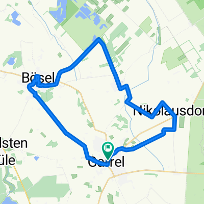
art der Tour ist in Garrel. Von dort fahren Sie in westliche Richtung. Sie radeln vorbei am Richtmoor und gelangen so nach Bösel. Die Strecke führt Sie durch den schön angelegten Dorfpark und dann weiter durch den Ortskern. Hier haben Sie Gelegenheit, eine Pause einzulegen.
Sie verlassen Bösel in Richtung Osterloh und erreichen die nächsten Alleen. Schließlich durchfahren Sie die Orte Petersdorf und Nikolausdorf. Letzterer ist insbesondere bei Kindern bekannt. Jedes Jahr schicken Kinder in der Weihnachtszeit ihre Wunschzettel an das Nikolausbüro.
Vorbei am Lether Feld fahren Sie zu Ihrem Ausgangspunkt zurück.
- -:--
- Duration
- 30.9 km
- Distance
- 24 m
- Ascent
- 27 m
- Descent
- ---
- Avg. speed
- ---
- Max. altitude

Route quality
Waytypes & surfaces along the route
Waytypes
Quiet road
21 km
(68 %)
Path
5.2 km
(17 %)
Surfaces
Paved
29.5 km
(96 %)
Unpaved
0 km
(<1 %)
Asphalt
26.2 km
(85 %)
Paving stones
3.2 km
(10 %)
Continue with Bikemap
Use, edit, or download this cycling route
You would like to ride Alleenroute or customize it for your own trip? Here is what you can do with this Bikemap route:
Free features
- Save this route as favorite or in collections
- Copy & plan your own version of this route
- Sync your route with Garmin or Wahoo
Premium features
Free trial for 3 days, or one-time payment. More about Bikemap Premium.
- Navigate this route on iOS & Android
- Export a GPX / KML file of this route
- Create your custom printout (try it for free)
- Download this route for offline navigation
Discover more Premium features.
Get Bikemap PremiumFrom our community
Other popular routes starting in Garrel
 Alleenroute
- Distance
- 30.9 km
- Ascent
- 24 m
- Descent
- 27 m
- Location
- Garrel, Lower Saxony, Germany
 Thülsfelder Talsperr Tour
- Distance
- 38.1 km
- Ascent
- 80 m
- Descent
- 79 m
- Location
- Garrel, Lower Saxony, Germany
 Garrel
- Distance
- 20.9 km
- Ascent
- 29 m
- Descent
- 26 m
- Location
- Garrel, Lower Saxony, Germany
 Alleenroute - Rundtour im Erholungsgebiet Thülsfelder Talsperre
- Distance
- 32 km
- Ascent
- 32 m
- Descent
- 34 m
- Location
- Garrel, Lower Saxony, Germany
 Thule
Thule- Distance
- 15.8 km
- Ascent
- 4 m
- Descent
- 12 m
- Location
- Garrel, Lower Saxony, Germany
 Am Stausee 10, Friesoythe do Breslauer Straße 5, Garrel
- Distance
- 36.4 km
- Ascent
- 7 m
- Descent
- 27 m
- Location
- Garrel, Lower Saxony, Germany
 Garrel-Athen-Brindisi-Garrel
- Distance
- 6,297.1 km
- Ascent
- 5,508 m
- Descent
- 5,508 m
- Location
- Garrel, Lower Saxony, Germany
 Ahlhorner Teiche 16
- Distance
- 16.4 km
- Ascent
- 56 m
- Descent
- 57 m
- Location
- Garrel, Lower Saxony, Germany
Open it in the app