

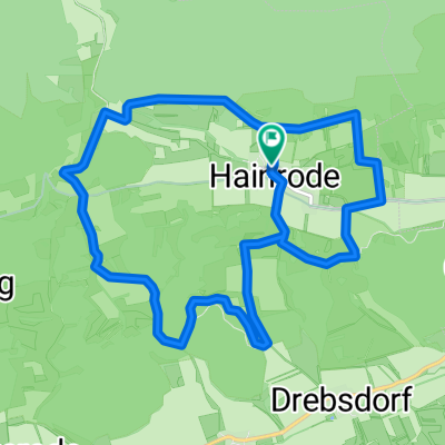
Hainrode-Pölsfeld Karstwanderweg Teil 5
A cycling route starting in Wallhausen, Saxony-Anhalt, Germany.
Overview
About this route
The Karstwanderweg is a long-distance trail in the South Harz that connects the districts of Osterode (Lower Saxony), Nordhausen (Thuringia), and Mansfelder Land (Saxony-Anhalt) over more than 250 km.
- -:--
- Duration
- 19.2 km
- Distance
- 382 m
- Ascent
- 412 m
- Descent
- ---
- Avg. speed
- ---
- Max. altitude
Continue with Bikemap
Use, edit, or download this cycling route
You would like to ride Hainrode-Pölsfeld Karstwanderweg Teil 5 or customize it for your own trip? Here is what you can do with this Bikemap route:
Free features
- Save this route as favorite or in collections
- Copy & plan your own version of this route
- Sync your route with Garmin or Wahoo
Premium features
Free trial for 3 days, or one-time payment. More about Bikemap Premium.
- Navigate this route on iOS & Android
- Export a GPX / KML file of this route
- Create your custom printout (try it for free)
- Download this route for offline navigation
Discover more Premium features.
Get Bikemap PremiumFrom our community
Other popular routes starting in Wallhausen
 SGH 004: Wanderrunde Hainrode
- Distance
- 12.9 km
- Ascent
- 340 m
- Descent
- 340 m
- Location
- Wallhausen, Saxony-Anhalt, Germany
 Wallhausen - Mühlhausen
- Distance
- 85.8 km
- Ascent
- 539 m
- Descent
- 446 m
- Location
- Wallhausen, Saxony-Anhalt, Germany
 Hauptstraße, Wallhausen nach Breitunger Oberdorf, Südharz
- Distance
- 17.5 km
- Ascent
- 391 m
- Descent
- 250 m
- Location
- Wallhausen, Saxony-Anhalt, Germany
 Heik 17, Sangerhausen nach Nordhäuser Straße 1, Berga
- Distance
- 16.4 km
- Ascent
- 37 m
- Descent
- 95 m
- Location
- Wallhausen, Saxony-Anhalt, Germany
 Wallhausen nach Hauptstraße, Wallhausen
- Distance
- 4.8 km
- Ascent
- 29 m
- Descent
- 201 m
- Location
- Wallhausen, Saxony-Anhalt, Germany
 Am Flutgraben 2, Wallhausen nach Am Flutgraben 14, Wallhausen
- Distance
- 28.3 km
- Ascent
- 945 m
- Descent
- 945 m
- Location
- Wallhausen, Saxony-Anhalt, Germany
 Knarrhügel, Brücken-Hackpfüffel nach Hackpfüfflischer Weg, Brücken-Hackpfüffel
- Distance
- 4.9 km
- Ascent
- 0 m
- Descent
- 0 m
- Location
- Wallhausen, Saxony-Anhalt, Germany
 Poststraße 199, Wallhausen nach Kantstraße 39, Leipzig
- Distance
- 102.8 km
- Ascent
- 474 m
- Descent
- 495 m
- Location
- Wallhausen, Saxony-Anhalt, Germany
Open it in the app