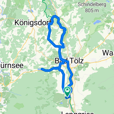
Blomberghaus - Hochtannenkopf-Runde
A cycling route starting in Wackersberg, Bavaria, Germany.
Overview
About this route
Untergrund:
Asphalt: 7,4km
Forstweg /Schotter 20,5 km
Trails 2,6 km
kurzes Schiebestück durch einen Bachgraben im zweiten Trailabschnitt
Â
- -:--
- Duration
- 28.4 km
- Distance
- 923 m
- Ascent
- 923 m
- Descent
- ---
- Avg. speed
- ---
- Avg. speed
Continue with Bikemap
Use, edit, or download this cycling route
You would like to ride Blomberghaus - Hochtannenkopf-Runde or customize it for your own trip? Here is what you can do with this Bikemap route:
Free features
- Save this route as favorite or in collections
- Copy & plan your own version of this route
- Sync your route with Garmin or Wahoo
Premium features
Free trial for 3 days, or one-time payment. More about Bikemap Premium.
- Navigate this route on iOS & Android
- Export a GPX / KML file of this route
- Create your custom printout (try it for free)
- Download this route for offline navigation
Discover more Premium features.
Get Bikemap PremiumFrom our community
Other popular routes starting in Wackersberg
- Mit dem MTB um den Hochtannenkopf
- Distance
- 28.8 km
- Ascent
- 960 m
- Descent
- 961 m
- Location
- Wackersberg, Bavaria, Germany
- Blomberg
- Distance
- 14.9 km
- Ascent
- 736 m
- Descent
- 733 m
- Location
- Wackersberg, Bavaria, Germany
- Lengries-Walchensee-Mittenwald-Sylvensteinstausee-Lenggries
- Distance
- 110.2 km
- Ascent
- 366 m
- Descent
- 367 m
- Location
- Wackersberg, Bavaria, Germany
- Blombergrunde
- Distance
- 21.2 km
- Ascent
- 708 m
- Descent
- 707 m
- Location
- Wackersberg, Bavaria, Germany
- 7. Stallau-Murnau-43km-329Hm
- Distance
- 43.2 km
- Ascent
- 271 m
- Descent
- 352 m
- Location
- Wackersberg, Bavaria, Germany
- Radltour Bad Tölz - Lenggries
- Distance
- 38.4 km
- Ascent
- 270 m
- Descent
- 268 m
- Location
- Wackersberg, Bavaria, Germany
- achensee lenggries
- Distance
- 46.5 km
- Ascent
- 681 m
- Descent
- 412 m
- Location
- Wackersberg, Bavaria, Germany
- Tölz-Osterseen-Tölz
- Distance
- 74.4 km
- Ascent
- 400 m
- Descent
- 400 m
- Location
- Wackersberg, Bavaria, Germany
Open it in the app